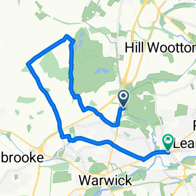
Route 8 (Budbrooke)
A cycling route starting in Warwick, England, United Kingdom.
Overview
About this route
Start: Priory Park/The Cape, Warwick
Finish: The Green, Snitterfield
Route: Cape Road, St. Michael’s Road, Birmingham Road, cycle path to Old Budbrooke Road, Warwick Parkway, Hampton Magna, Church Lane, Budbrooke, Woodway, Hampton on the Hill, Old School Lane, Henley Road, Warwick Road, Littleworth, Norton Lindsey, Wolverton Road, Wolverton, Snitterfield
- -:--
- Duration
- 14.3 km
- Distance
- 122 m
- Ascent
- 111 m
- Descent
- ---
- Avg. speed
- ---
- Avg. speed
Route quality
Waytypes & surfaces along the route
Waytypes
Road
11.2 km
(79 %)
Quiet road
2.1 km
(15 %)
Surfaces
Paved
7.1 km
(50 %)
Asphalt
7 km
(49 %)
Paved (undefined)
0.1 km
(<1 %)
Undefined
7.2 km
(50 %)
Continue with Bikemap
Use, edit, or download this cycling route
You would like to ride Route 8 (Budbrooke) or customize it for your own trip? Here is what you can do with this Bikemap route:
Free features
- Save this route as favorite or in collections
- Copy & plan your own version of this route
- Sync your route with Garmin or Wahoo
Premium features
Free trial for 3 days, or one-time payment. More about Bikemap Premium.
- Navigate this route on iOS & Android
- Export a GPX / KML file of this route
- Create your custom printout (try it for free)
- Download this route for offline navigation
Discover more Premium features.
Get Bikemap PremiumFrom our community
Other popular routes starting in Warwick
- Route 16 (Wilmcote)
- Distance
- 16.5 km
- Ascent
- 138 m
- Descent
- 154 m
- Location
- Warwick, England, United Kingdom
- Route 14 (Aston Cantlow)
- Distance
- 15.8 km
- Ascent
- 110 m
- Descent
- 119 m
- Location
- Warwick, England, United Kingdom
- Route 18 (Stratford-upon-Avon)
- Distance
- 19 km
- Ascent
- 104 m
- Descent
- 114 m
- Location
- Warwick, England, United Kingdom
- Day 2 - Warwick to Cirencester
- Distance
- 93 km
- Ascent
- 826 m
- Descent
- 762 m
- Location
- Warwick, England, United Kingdom
- Route 11 (Rouncil Lane)
- Distance
- 16.5 km
- Ascent
- 115 m
- Descent
- 121 m
- Location
- Warwick, England, United Kingdom
- Route 15 (Lowsonford)
- Distance
- 15.6 km
- Ascent
- 144 m
- Descent
- 136 m
- Location
- Warwick, England, United Kingdom
- Roads to Cath and Steve
- Distance
- 18.8 km
- Ascent
- 46 m
- Descent
- 79 m
- Location
- Warwick, England, United Kingdom
- Route 10 (Shrewley)
- Distance
- 14.1 km
- Ascent
- 97 m
- Descent
- 110 m
- Location
- Warwick, England, United Kingdom
Open it in the app