Route 9 (Hampton Lucy)
A cycling route starting in Warwick, England, United Kingdom.
Overview
About this route
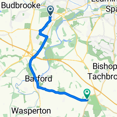
Start: Market Square, Warwick
Finish: Hatton Bank/Black Hill Garden Centre
Route: Market Street, Theatre Street, Linen Street, Racecourse, Hampton Road cycle path, Robins Grove, Purser Drive, Tapping Way, Stratford Road, Longbridge M40 cycle path, Sherbourne, Hampton Lucy, Stratford Road, Hatton Bank Lane Â
- -:--
- Duration
- 14.1 km
- Distance
- 103 m
- Ascent
- 82 m
- Descent
- ---
- Avg. speed
- ---
- Max. altitude
Route quality
Waytypes & surfaces along the route
Waytypes
Quiet road
11.6 km
(82 %)
Cycleway
2 km
(14 %)
Surfaces
Paved
5.4 km
(38 %)
Asphalt
3.9 km
(28 %)
Paved (undefined)
1.4 km
(10 %)
Undefined
8.7 km
(62 %)
Continue with Bikemap
Use, edit, or download this cycling route
You would like to ride Route 9 (Hampton Lucy) or customize it for your own trip? Here is what you can do with this Bikemap route:
Free features
- Save this route as favorite or in collections
- Copy & plan your own version of this route
- Sync your route with Garmin or Wahoo
Premium features
Free trial for 3 days, or one-time payment. More about Bikemap Premium.
- Navigate this route on iOS & Android
- Export a GPX / KML file of this route
- Create your custom printout (try it for free)
- Download this route for offline navigation
Discover more Premium features.
Get Bikemap PremiumFrom our community
Other popular routes starting in Warwick
Day 2 - Warwick to Cirencester- Distance
- 93 km
- Ascent
- 826 m
- Descent
- 762 m
- Location
- Warwick, England, United Kingdom
Route 18 (Stratford-upon-Avon)- Distance
- 19 km
- Ascent
- 104 m
- Descent
- 114 m
- Location
- Warwick, England, United Kingdom
Route 12 (Norton Lindsey)- Distance
- 15.8 km
- Ascent
- 132 m
- Descent
- 134 m
- Location
- Warwick, England, United Kingdom
Route 10 (Shrewley)- Distance
- 14.1 km
- Ascent
- 97 m
- Descent
- 110 m
- Location
- Warwick, England, United Kingdom
Route 7 (Warwick Parkway)- Distance
- 13.1 km
- Ascent
- 127 m
- Descent
- 117 m
- Location
- Warwick, England, United Kingdom
Roads to Cath and Steve- Distance
- 18.8 km
- Ascent
- 46 m
- Descent
- 79 m
- Location
- Warwick, England, United Kingdom
Route 16 (Wilmcote)- Distance
- 16.5 km
- Ascent
- 138 m
- Descent
- 154 m
- Location
- Warwick, England, United Kingdom
Route to 133 Warwick New Road, Royal Leamington Spa- Distance
- 11.9 km
- Ascent
- 104 m
- Descent
- 95 m
- Location
- Warwick, England, United Kingdom
Open it in the app


