

Route 16 (Wilmcote)
A cycling route starting in Warwick, England, United Kingdom.
Overview
About this route
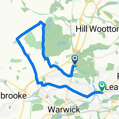
Start: Ugly Bridge Road, Hatton Park
Finish: Mary Arden House, Wilmcote
Route: Ugly Bridge Road cycle path, (A4177 crossing), Woodway, Hampton on the Hill, Old School Lane, Henley Road, Warwick Road, Littleworth, New Road, Norton Lindsey, Snitterfield Lane, Snitterfield, Bell Lane, School Road, The Green, Gospel Oak Lane, Pathlow, A3400 Birmingham Road, Featherbed Lane, Wilmcote
- -:--
- Duration
- 16.5 km
- Distance
- 138 m
- Ascent
- 154 m
- Descent
- ---
- Avg. speed
- ---
- Max. altitude

Route quality
Waytypes & surfaces along the route
Waytypes
Quiet road
7.6 km
(46 %)
Road
6.3 km
(38 %)
Surfaces
Paved
5.4 km
(33 %)
Asphalt
4.6 km
(28 %)
Paved (undefined)
0.8 km
(5 %)
Undefined
11.1 km
(67 %)
Continue with Bikemap
Use, edit, or download this cycling route
You would like to ride Route 16 (Wilmcote) or customize it for your own trip? Here is what you can do with this Bikemap route:
Free features
- Save this route as favorite or in collections
- Copy & plan your own version of this route
- Sync your route with Garmin or Wahoo
Premium features
Free trial for 3 days, or one-time payment. More about Bikemap Premium.
- Navigate this route on iOS & Android
- Export a GPX / KML file of this route
- Create your custom printout (try it for free)
- Download this route for offline navigation
Discover more Premium features.
Get Bikemap PremiumFrom our community
Other popular routes starting in Warwick
 Route 10 (Shrewley)
- Distance
- 14.1 km
- Ascent
- 97 m
- Descent
- 110 m
- Location
- Warwick, England, United Kingdom
 Route 16 (Wilmcote)
- Distance
- 16.5 km
- Ascent
- 138 m
- Descent
- 154 m
- Location
- Warwick, England, United Kingdom
 Route to 133 Warwick New Road, Royal Leamington Spa
- Distance
- 11.9 km
- Ascent
- 104 m
- Descent
- 95 m
- Location
- Warwick, England, United Kingdom
 Route 8 (Budbrooke)
- Distance
- 14.3 km
- Ascent
- 122 m
- Descent
- 111 m
- Location
- Warwick, England, United Kingdom
 Route 15 (Lowsonford)
- Distance
- 15.6 km
- Ascent
- 144 m
- Descent
- 136 m
- Location
- Warwick, England, United Kingdom
 Route 7 (Warwick Parkway)
- Distance
- 13.1 km
- Ascent
- 127 m
- Descent
- 117 m
- Location
- Warwick, England, United Kingdom
 Warwick to Kenilworth
- Distance
- 7.4 km
- Ascent
- 56 m
- Descent
- 32 m
- Location
- Warwick, England, United Kingdom
 Day 2 - Warwick to Cirencester
- Distance
- 93 km
- Ascent
- 826 m
- Descent
- 762 m
- Location
- Warwick, England, United Kingdom
Open it in the app