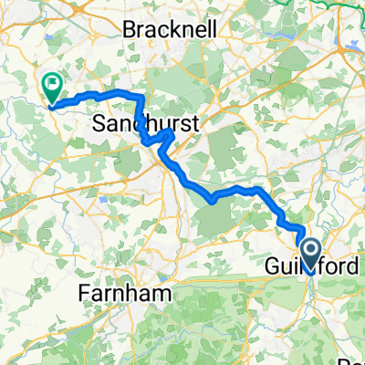
GB's Guildford - Shoreham- Brighton; 72km/44m
A cycling route starting in Guildford, England, United Kingdom.
Overview
About this route
72.3 km = 43.8 miles
- -:--
- Duration
- 70.2 km
- Distance
- 176 m
- Ascent
- 170 m
- Descent
- ---
- Avg. speed
- ---
- Avg. speed
Route quality
Waytypes & surfaces along the route
Waytypes
Cycleway
51.2 km
(73 %)
Busy road
6.3 km
(9 %)
Surfaces
Paved
17.3 km
(25 %)
Unpaved
27.8 km
(40 %)
Gravel
25.1 km
(36 %)
Asphalt
16.3 km
(23 %)
Route highlights
Points of interest along the route
Point of interest after 0.7 km
GUILDFORD Tea/Coffee @ 34km L / 68km B
Point of interest after 18.7 km
OLD TUNNEL DIVERSION
Point of interest after 32.7 km
TIPSY FOX INN - Lunch @ 20m
Point of interest after 40.9 km
PARTRIDGE GREEN (Stan's Bike Shack) Tea/Coffee @ 75km L / 27km B
Continue with Bikemap
Use, edit, or download this cycling route
You would like to ride GB's Guildford - Shoreham- Brighton; 72km/44m or customize it for your own trip? Here is what you can do with this Bikemap route:
Free features
- Save this route as favorite or in collections
- Copy & plan your own version of this route
- Sync your route with Garmin or Wahoo
Premium features
Free trial for 3 days, or one-time payment. More about Bikemap Premium.
- Navigate this route on iOS & Android
- Export a GPX / KML file of this route
- Create your custom printout (try it for free)
- Download this route for offline navigation
Discover more Premium features.
Get Bikemap PremiumFrom our community
Other popular routes starting in Guildford
- Guildford circular
- Distance
- 29.8 km
- Ascent
- 177 m
- Descent
- 180 m
- Location
- Guildford, England, United Kingdom
- Hascombe loop
- Distance
- 28 km
- Ascent
- 305 m
- Descent
- 239 m
- Location
- Guildford, England, United Kingdom
- GB's Guildford - Shoreham- Brighton; 72km/44m
- Distance
- 70.2 km
- Ascent
- 176 m
- Descent
- 170 m
- Location
- Guildford, England, United Kingdom
- oval to gym
- Distance
- 1.6 km
- Ascent
- 12 m
- Descent
- 35 m
- Location
- Guildford, England, United Kingdom
- Guildford to Puttenham and back
- Distance
- 26.1 km
- Ascent
- 336 m
- Descent
- 311 m
- Location
- Guildford, England, United Kingdom
- Lower Edgeborough Road 9 to Lower Edgeborough Road 9
- Distance
- 21.7 km
- Ascent
- 334 m
- Descent
- 328 m
- Location
- Guildford, England, United Kingdom
- Surry Hills West Original
- Distance
- 56.2 km
- Ascent
- 595 m
- Descent
- 592 m
- Location
- Guildford, England, United Kingdom
- MTB-Guildford South Looop
- Distance
- 56.3 km
- Ascent
- 622 m
- Descent
- 623 m
- Location
- Guildford, England, United Kingdom
Open it in the app