

Dracula Run day 1.
A cycling route starting in Hathern, England, United Kingdom.
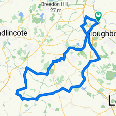
Overview
About this route
Day 1 of 2. Run to Whitby.
- -:--
- Duration
- 165.3 km
- Distance
- 265 m
- Ascent
- 287 m
- Descent
- ---
- Avg. speed
- ---
- Max. altitude
Route quality
Waytypes & surfaces along the route
Waytypes
Road
97.5 km
(59 %)
Quiet road
31.4 km
(19 %)
Surfaces
Paved
28.1 km
(17 %)
Unpaved
1.7 km
(1 %)
Asphalt
23.1 km
(14 %)
Paved (undefined)
5 km
(3 %)
Route highlights
Points of interest along the route
Point of interest after 102.9 km
Food stop The Pantry 8020. 27 Grovewood Rd, Misterton, Doncaster DN10 4EF
Accommodation after 165.3 km
Mercure Hull, Grange Park Lane, Willerby, Hull, HU10 6EB, United Kingdom
Continue with Bikemap
Use, edit, or download this cycling route
You would like to ride Dracula Run day 1. or customize it for your own trip? Here is what you can do with this Bikemap route:
Free features
- Save this route as favorite or in collections
- Copy & plan your own version of this route
- Split it into stages to create a multi-day tour
- Sync your route with Garmin or Wahoo
Premium features
Free trial for 3 days, or one-time payment. More about Bikemap Premium.
- Navigate this route on iOS & Android
- Export a GPX / KML file of this route
- Create your custom printout (try it for free)
- Download this route for offline navigation
Discover more Premium features.
Get Bikemap PremiumFrom our community
Other popular routes starting in Hathern
 Loughborough - Barrow Canal side CAKE loop
- Distance
- 20.6 km
- Ascent
- 29 m
- Descent
- 32 m
- Location
- Hathern, England, United Kingdom
 Harvey's Coffee Cabin trip
- Distance
- 73.9 km
- Ascent
- 418 m
- Descent
- 418 m
- Location
- Hathern, England, United Kingdom
 Zouch Loop 3
- Distance
- 63.6 km
- Ascent
- 385 m
- Descent
- 384 m
- Location
- Hathern, England, United Kingdom
 P2L June
- Distance
- 100.6 km
- Ascent
- 495 m
- Descent
- 506 m
- Location
- Hathern, England, United Kingdom
 Dracula Run day 1.
- Distance
- 165.3 km
- Ascent
- 265 m
- Descent
- 287 m
- Location
- Hathern, England, United Kingdom
 Loughborough - Sileby CAKE loop
- Distance
- 29.1 km
- Ascent
- 106 m
- Descent
- 106 m
- Location
- Hathern, England, United Kingdom
 Zouch loop 2
- Distance
- 32.8 km
- Ascent
- 128 m
- Descent
- 127 m
- Location
- Hathern, England, United Kingdom
 Loughborough - St Josephs CAKE loop
- Distance
- 22 km
- Ascent
- 205 m
- Descent
- 206 m
- Location
- Hathern, England, United Kingdom
Open it in the app