

Tour de Vysočina 2008
A cycling route starting in Polička, Pardubický kraj, Czechia.
Overview
About this route
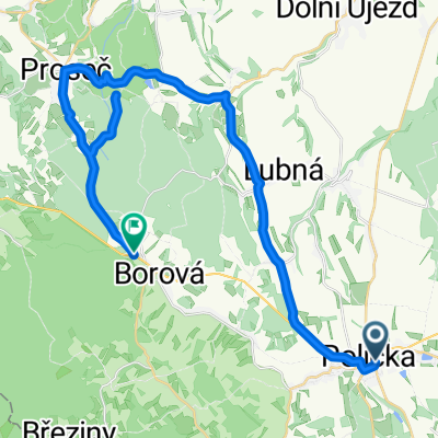
Tour de Vysočina 2008
Lucký Vrch - Jimramov - Dalečín - Vír - Bystřice n. Perštejnem - Nové Město na Moravě - Sněžné - Svratka - Borová - Lucký Vrch (100km)
- -:--
- Duration
- 100.9 km
- Distance
- 1,865 m
- Ascent
- 1,902 m
- Descent
- ---
- Avg. speed
- 795 m
- Max. altitude

Route quality
Waytypes & surfaces along the route
Waytypes
Road
17.1 km
(17 %)
Quiet road
4 km
(4 %)
Surfaces
Paved
28.2 km
(28 %)
Unpaved
2 km
(2 %)
Asphalt
28.2 km
(28 %)
Ground
2 km
(2 %)
Undefined
70.6 km
(70 %)
Continue with Bikemap
Use, edit, or download this cycling route
You would like to ride Tour de Vysočina 2008 or customize it for your own trip? Here is what you can do with this Bikemap route:
Free features
- Save this route as favorite or in collections
- Copy & plan your own version of this route
- Split it into stages to create a multi-day tour
- Sync your route with Garmin or Wahoo
Premium features
Free trial for 3 days, or one-time payment. More about Bikemap Premium.
- Navigate this route on iOS & Android
- Export a GPX / KML file of this route
- Create your custom printout (try it for free)
- Download this route for offline navigation
Discover more Premium features.
Get Bikemap PremiumFrom our community
Other popular routes starting in Polička
 Polička - Bystřice nad Pernštejnem, pěšky
- Distance
- 31.4 km
- Ascent
- 564 m
- Descent
- 552 m
- Location
- Polička, Pardubický kraj, Czechia
 TRIATLON VYZRÁLÝCH MUŽŮ - kolo
- Distance
- 26.8 km
- Ascent
- 291 m
- Descent
- 169 m
- Location
- Polička, Pardubický kraj, Czechia
 Budislav
- Distance
- 32 km
- Ascent
- 536 m
- Descent
- 448 m
- Location
- Polička, Pardubický kraj, Czechia
 Olympijský triatlon 2012 - kolo 40km
- Distance
- 39.3 km
- Ascent
- 363 m
- Descent
- 281 m
- Location
- Polička, Pardubický kraj, Czechia
 Široký Důl - Nové Hrady - Široký Důl
- Distance
- 41.4 km
- Ascent
- 602 m
- Descent
- 601 m
- Location
- Polička, Pardubický kraj, Czechia
 Milovy
- Distance
- 44.4 km
- Ascent
- 470 m
- Descent
- 470 m
- Location
- Polička, Pardubický kraj, Czechia
 Tour de Vysočina 2008
- Distance
- 100.9 km
- Ascent
- 1,865 m
- Descent
- 1,902 m
- Location
- Polička, Pardubický kraj, Czechia
 Polička - Tišnov přes hrad Svojanov
- Distance
- 60.5 km
- Ascent
- 1,006 m
- Descent
- 1,228 m
- Location
- Polička, Pardubický kraj, Czechia
Open it in the app