

TT PLAINPALAIS
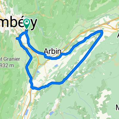
A cycling route starting in Challes-les-Eaux, Auvergne-Rhône-Alpes, France.
Overview
About this route
This Circuit of the Grand Massif makes a welcome
return in 2011. Some fantastic alpine scenery on this lovely ride.
- -:--
- Duration
- 61.3 km
- Distance
- 1,418 m
- Ascent
- 1,418 m
- Descent
- ---
- Avg. speed
- ---
- Max. altitude

Route quality
Waytypes & surfaces along the route
Waytypes
Busy road
43.5 km
(71 %)
Road
10.8 km
(18 %)
Surfaces
Paved
54.2 km
(88 %)
Unpaved
2.1 km
(3 %)
Asphalt
54.2 km
(88 %)
Ground
1.5 km
(3 %)
Continue with Bikemap
Use, edit, or download this cycling route
You would like to ride TT PLAINPALAIS or customize it for your own trip? Here is what you can do with this Bikemap route:
Free features
- Save this route as favorite or in collections
- Copy & plan your own version of this route
- Sync your route with Garmin or Wahoo
Premium features
Free trial for 3 days, or one-time payment. More about Bikemap Premium.
- Navigate this route on iOS & Android
- Export a GPX / KML file of this route
- Create your custom printout (try it for free)
- Download this route for offline navigation
Discover more Premium features.
Get Bikemap PremiumFrom our community
Other popular routes starting in Challes-les-Eaux
 From Challes-les-Eaux to Porte-de-Savoie
- Distance
- 9.4 km
- Ascent
- 94 m
- Descent
- 74 m
- Location
- Challes-les-Eaux, Auvergne-Rhône-Alpes, France
 Alpes Chambéry / Il était une fois une jolie balade au Pays des Bauges (Frêne - Lindar - Prés) ... qui s'est terminée sous l'orage !
- Distance
- 89 km
- Ascent
- 1,699 m
- Descent
- 1,699 m
- Location
- Challes-les-Eaux, Auvergne-Rhône-Alpes, France
 TT ST MICHAELS MT
- Distance
- 16.5 km
- Ascent
- 437 m
- Descent
- 445 m
- Location
- Challes-les-Eaux, Auvergne-Rhône-Alpes, France
 challes - col de Marocaz
- Distance
- 41.8 km
- Ascent
- 799 m
- Descent
- 800 m
- Location
- Challes-les-Eaux, Auvergne-Rhône-Alpes, France
 La féclaz
- Distance
- 60.5 km
- Ascent
- 1,306 m
- Descent
- 1,301 m
- Location
- Challes-les-Eaux, Auvergne-Rhône-Alpes, France
 TT ISIERE
- Distance
- 64.6 km
- Ascent
- 395 m
- Descent
- 395 m
- Location
- Challes-les-Eaux, Auvergne-Rhône-Alpes, France
 From Challes-les-Eaux to Porte-de-Savoie
- Distance
- 9.4 km
- Ascent
- 94 m
- Descent
- 74 m
- Location
- Challes-les-Eaux, Auvergne-Rhône-Alpes, France
 TT COL DU MAROCAZ
- Distance
- 39.8 km
- Ascent
- 818 m
- Descent
- 818 m
- Location
- Challes-les-Eaux, Auvergne-Rhône-Alpes, France
Open it in the app