

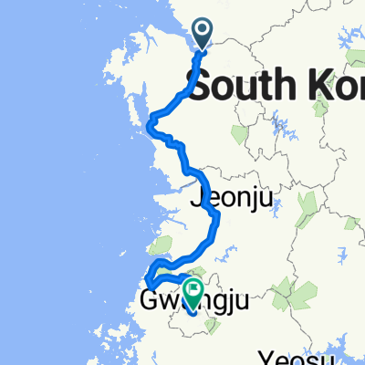
маршрут с Sinchang-myeon 17, Asan-si
A cycling route starting in Asan, Chungcheongnam-do, South Korea.
Overview
About this route
- 25 min
- Duration
- 7.1 km
- Distance
- 67 m
- Ascent
- 86 m
- Descent
- 17.1 km/h
- Avg. speed
- ---
- Max. altitude

Route quality
Waytypes & surfaces along the route
Waytypes
Quiet road
2.3 km
(32 %)
Road
0.3 km
(4 %)
Continue with Bikemap
Use, edit, or download this cycling route
You would like to ride маршрут с Sinchang-myeon 17, Asan-si or customize it for your own trip? Here is what you can do with this Bikemap route:
Free features
- Save this route as favorite or in collections
- Copy & plan your own version of this route
- Sync your route with Garmin or Wahoo
Premium features
Free trial for 3 days, or one-time payment. More about Bikemap Premium.
- Navigate this route on iOS & Android
- Export a GPX / KML file of this route
- Create your custom printout (try it for free)
- Download this route for offline navigation
Discover more Premium features.
Get Bikemap PremiumFrom our community
Other popular routes starting in Asan
 2025.9.9
- Distance
- 46.2 km
- Ascent
- 198 m
- Descent
- 248 m
- Location
- Asan, Chungcheongnam-do, South Korea
 work route main
- Distance
- 15.5 km
- Ascent
- 129 m
- Descent
- 177 m
- Location
- Asan, Chungcheongnam-do, South Korea
 2025.9.7 저녁
- Distance
- 30.4 km
- Ascent
- 184 m
- Descent
- 223 m
- Location
- Asan, Chungcheongnam-do, South Korea
 маршрут с Sinchang-myeon 17, Asan-si
- Distance
- 7.1 km
- Ascent
- 67 m
- Descent
- 86 m
- Location
- Asan, Chungcheongnam-do, South Korea
 От 307-3 권곡동, 아산시 до 697 신부동, 천안시
- Distance
- 20.3 km
- Ascent
- 1,075 m
- Descent
- 1,040 m
- Location
- Asan, Chungcheongnam-do, South Korea
 159, 평택호길, 평택시 to 52-55, 창내리, 평택시
- Distance
- 19.1 km
- Ascent
- 126 m
- Descent
- 129 m
- Location
- Asan, Chungcheongnam-do, South Korea
 2025.8.28오후
- Distance
- 44.8 km
- Ascent
- 199 m
- Descent
- 194 m
- Location
- Asan, Chungcheongnam-do, South Korea
 pilgrim of winniethepoo family
- Distance
- 338.6 km
- Ascent
- 3,529 m
- Descent
- 3,512 m
- Location
- Asan, Chungcheongnam-do, South Korea
Open it in the app