

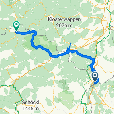
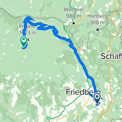
Pinggau - Hochwechsel-Pinggau
A cycling route starting in Pinggau, Styria, Austria.
Overview
About this route
Schöne Bike-Route abseits vom Tourismus.
Zeit: ca. 4 - 5 Std. hin und zurück.
Viel Spass.
- -:--
- Duration
- 41.5 km
- Distance
- 1,477 m
- Ascent
- 266 m
- Descent
- ---
- Avg. speed
- ---
- Max. altitude
Route quality
Waytypes & surfaces along the route
Waytypes
Track
24.2 km
(58 %)
Quiet road
17.3 km
(42 %)
Surfaces
Unpaved
23.6 km
(57 %)
Gravel
19.4 km
(47 %)
Unpaved (undefined)
3.8 km
(9 %)
Route highlights
Points of interest along the route
Point of interest after 2.4 km
Bei starker Rechtskurve, links über Brücke der Asphaltstraße entlang.
Point of interest after 3.3 km
Altes Sägewerk (Hundsmüller).
Point of interest after 6.5 km
Parkplätze hinter Kirche bei Kinderspielplatz.
Point of interest after 13.2 km
Beginn Asphaltstraße nach Baumgarten.
Point of interest after 14.3 km
Bei Feuerwehrhalle Links den Asphaltweg entlang.
Point of interest after 14.8 km
Rechts den Forstweg entlang.
Point of interest after 15.8 km
Bei Forststrasse rechts nach markierter Eisenstange durch den Wald (Traktorstrasse ca. 100m bis zum Beginn einer breiten Forststrasse). ca. 1000HM
Point of interest after 18.3 km
Fischteiche Glashütte.
Point of interest after 18.6 km
Forstverwaltungsgebäude.
Point of interest after 26.3 km
Schranken.
Point of interest after 26.9 km
Kleine Holzhütte.
Point of interest after 27.5 km
Kreuzung links Richtung Hallerhaus.
Point of interest after 28.2 km
Hallerhaus ca. 1.400HM.
Point of interest after 28.7 km
Stoaalm. (Riesige Holzhütte!)
Point of interest after 28.8 km
Liftstation Panoramabahn.
Point of interest after 28.9 km
Beginn Langlaufloipe ca. 7km bis Marienseer Schwaig.
Point of interest after 40.1 km
Weidezäune!
Continue with Bikemap
Use, edit, or download this cycling route
You would like to ride Pinggau - Hochwechsel-Pinggau or customize it for your own trip? Here is what you can do with this Bikemap route:
Free features
- Save this route as favorite or in collections
- Copy & plan your own version of this route
- Sync your route with Garmin or Wahoo
Premium features
Free trial for 3 days, or one-time payment. More about Bikemap Premium.
- Navigate this route on iOS & Android
- Export a GPX / KML file of this route
- Create your custom printout (try it for free)
- Download this route for offline navigation
Discover more Premium features.
Get Bikemap PremiumFrom our community
Other popular routes starting in Pinggau
 Sparberegg 16 nach Grazer Straße 7, Mariazell
- Distance
- 117.5 km
- Ascent
- 3,101 m
- Descent
- 2,941 m
- Location
- Pinggau, Styria, Austria
 Pinggau-Gillersdorf
- Distance
- 68.8 km
- Ascent
- 150 m
- Descent
- 412 m
- Location
- Pinggau, Styria, Austria
 Pinggau - Hochwechsel-Pinggau
- Distance
- 41.5 km
- Ascent
- 1,477 m
- Descent
- 266 m
- Location
- Pinggau, Styria, Austria
 Tour de Italia 2017 dzień 2
- Distance
- 133.1 km
- Ascent
- 867 m
- Descent
- 1,041 m
- Location
- Pinggau, Styria, Austria
 Haideggendorf 23 nach Haideggendorf 80
- Distance
- 0 km
- Ascent
- 0 m
- Descent
- 0 m
- Location
- Pinggau, Styria, Austria
 Haideggendorf trahütte vorauer schwaig
- Distance
- 22.9 km
- Ascent
- 1,051 m
- Descent
- 186 m
- Location
- Pinggau, Styria, Austria
 Mountains
- Distance
- 170.2 km
- Ascent
- 3,184 m
- Descent
- 3,184 m
- Location
- Pinggau, Styria, Austria
 Lechnerweg Ierfeld Weg nach Haideggendorf 22
- Distance
- 37.4 km
- Ascent
- 619 m
- Descent
- 630 m
- Location
- Pinggau, Styria, Austria
Open it in the app