

Der Mostbaron rund um Amstetten - 56,5km, 540hm
A cycling route starting in Amstetten, Lower Austria, Austria.
Overview
About this route
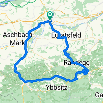
The 53-kilometer-long Mostbaron cycling route leads us into the world of those farmers who have dedicated themselves to the cultivation of apple must and thus hold the title of 'Mostbaron'. Along the predominantly hilly route – only two short sections run straight or slightly downhill – we can stop at numerous Moststraße taverns or visit one or another Moststraße heuriger and convince ourselves of the warmth and hospitality of the Mostviertler people. The typical square courtyards of the region, which we pass on this round tour, mainly date back to the 19th century, when must brought wealth to the farmers. Before we start the Mostbaron cycling route, we can get an impression of the production of must and its importance for the local population at the MostBirnHaus in Ardagger Stift (1). After that, we cycle through gently hilly terrain towards the southeast, with a steep ascent just before Viehdorf. Soon we will reach Seisenegg (2), which boasts a beautiful medieval castle, and then we come to Leutzmannsdorf (3). Crossing the Ybbs, we cycle to Pollenberg (4) and further to Euratsfeld (5). The tour again gently undulates southwest toward Neuhofen an der Ybbs (6), the 'cradle of Austria', where we can visit the Ostarrichi-Kulturhof. We have already completed more than half of the route when we reach Ulmerfeld (7). We cross the Ybbs for the last time and continue to Öhling (8). The section to Zeillern (9) is initially a bit more challenging, as it mostly goes uphill and we have to cover 200 meters of elevation to reach the highest point of the tour at 392 meters above sea level. After that, we roll down into the musical community with the well-known musical training center. From the northern Stephanshart (10), it is not far back to the starting point at the MostBirnHaus at Ardagger Stift (1).
- -:--
- Duration
- 56.5 km
- Distance
- 419 m
- Ascent
- 419 m
- Descent
- ---
- Avg. speed
- ---
- Max. altitude

Route quality
Waytypes & surfaces along the route
Waytypes
Road
39 km
(69 %)
Quiet road
9.6 km
(17 %)
Surfaces
Paved
15.8 km
(28 %)
Asphalt
15.8 km
(28 %)
Undefined
40.6 km
(72 %)
Continue with Bikemap
Use, edit, or download this cycling route
You would like to ride Der Mostbaron rund um Amstetten - 56,5km, 540hm or customize it for your own trip? Here is what you can do with this Bikemap route:
Free features
- Save this route as favorite or in collections
- Copy & plan your own version of this route
- Sync your route with Garmin or Wahoo
Premium features
Free trial for 3 days, or one-time payment. More about Bikemap Premium.
- Navigate this route on iOS & Android
- Export a GPX / KML file of this route
- Create your custom printout (try it for free)
- Download this route for offline navigation
Discover more Premium features.
Get Bikemap PremiumFrom our community
Other popular routes starting in Amstetten
 AM-Hochkogel-Gresten-WY-AM
- Distance
- 77.5 km
- Ascent
- 799 m
- Descent
- 799 m
- Location
- Amstetten, Lower Austria, Austria
 60er Ausfahrt Hannes
- Distance
- 112.3 km
- Ascent
- 1,091 m
- Descent
- 1,099 m
- Location
- Amstetten, Lower Austria, Austria
 Amstetten nach Pfaffenschlag
- Distance
- 47.5 km
- Ascent
- 700 m
- Descent
- 262 m
- Location
- Amstetten, Lower Austria, Austria
 Linz
Linz- Distance
- 115.4 km
- Ascent
- 105 m
- Descent
- 108 m
- Location
- Amstetten, Lower Austria, Austria
 amstetten-lunzer see-laubenbachmühle
- Distance
- 118.8 km
- Ascent
- 2,396 m
- Descent
- 2,135 m
- Location
- Amstetten, Lower Austria, Austria
 Der Mostbaron rund um Amstetten - 56,5km, 540hm
- Distance
- 56.5 km
- Ascent
- 419 m
- Descent
- 419 m
- Location
- Amstetten, Lower Austria, Austria
 07.15 Hochpyra
- Distance
- 43.5 km
- Ascent
- 715 m
- Descent
- 711 m
- Location
- Amstetten, Lower Austria, Austria
 Hochkogel
- Distance
- 29.7 km
- Ascent
- 497 m
- Descent
- 496 m
- Location
- Amstetten, Lower Austria, Austria
Open it in the app