
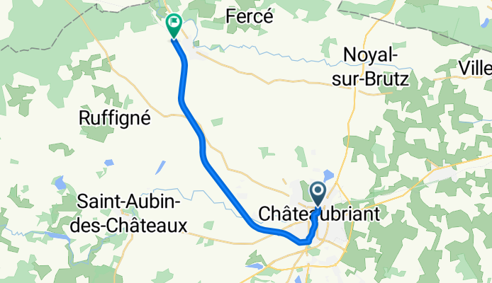
Itinéraire à partir de 15bis Rue Guy Môquet, Châteaubriant
A cycling route starting in Châteaubriant, Pays de la Loire Region, France.
Overview
About this route
- 55 min
- Duration
- 13.3 km
- Distance
- 69 m
- Ascent
- 77 m
- Descent
- 14.4 km/h
- Avg. speed
- ---
- Max. altitude
Route quality
Waytypes & surfaces along the route
Waytypes
Path
9.8 km
(74 %)
Quiet road
1.8 km
(14 %)
Surfaces
Paved
9.5 km
(72 %)
Unpaved
0.6 km
(5 %)
Asphalt
9.4 km
(71 %)
Gravel
0.6 km
(5 %)
Continue with Bikemap
Use, edit, or download this cycling route
You would like to ride Itinéraire à partir de 15bis Rue Guy Môquet, Châteaubriant or customize it for your own trip? Here is what you can do with this Bikemap route:
Free features
- Save this route as favorite or in collections
- Copy & plan your own version of this route
- Sync your route with Garmin or Wahoo
Premium features
Free trial for 3 days, or one-time payment. More about Bikemap Premium.
- Navigate this route on iOS & Android
- Export a GPX / KML file of this route
- Create your custom printout (try it for free)
- Download this route for offline navigation
Discover more Premium features.
Get Bikemap PremiumFrom our community
Other popular routes starting in Châteaubriant
 to la chapelle
- Distance
- 92.8 km
- Ascent
- 466 m
- Descent
- 502 m
- Location
- Châteaubriant, Pays de la Loire Region, France
 Heidelberg nach Westen Etappen 9-11
- Distance
- 279.7 km
- Ascent
- 723 m
- Descent
- 779 m
- Location
- Châteaubriant, Pays de la Loire Region, France
 14. Chateaubriant - Montigne le Brillant
- Distance
- 62.3 km
- Ascent
- 389 m
- Descent
- 388 m
- Location
- Châteaubriant, Pays de la Loire Region, France
 Day 2
Day 2- Distance
- 119.7 km
- Ascent
- 356 m
- Descent
- 327 m
- Location
- Châteaubriant, Pays de la Loire Region, France
 balade dimanche
- Distance
- 30 km
- Ascent
- 64 m
- Descent
- 131 m
- Location
- Châteaubriant, Pays de la Loire Region, France
 De Rue de Strasbourg 2, Châteaubriant à Rue du Frère Emery 2, Bain-de-Bretagne
- Distance
- 32.2 km
- Ascent
- 268 m
- Descent
- 247 m
- Location
- Châteaubriant, Pays de la Loire Region, France
 Day 2
Day 2- Distance
- 95.7 km
- Ascent
- 298 m
- Descent
- 313 m
- Location
- Châteaubriant, Pays de la Loire Region, France
 rando René Guy Cadou mixte
- Distance
- 33.9 km
- Ascent
- 321 m
- Descent
- 351 m
- Location
- Châteaubriant, Pays de la Loire Region, France
Open it in the app