

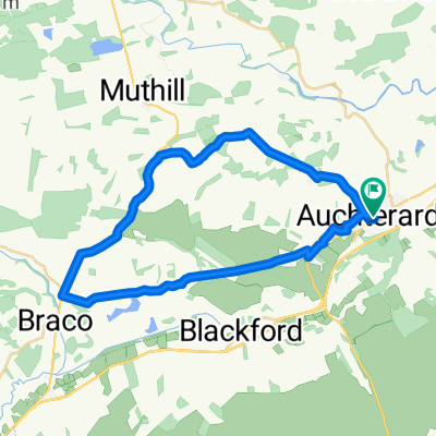
Auchterarder circular route 1
A cycling route starting in Auchterarder, Scotland, United Kingdom.
Overview
About this route
- 2 h 3 min
- Duration
- 41 km
- Distance
- 370 m
- Ascent
- 369 m
- Descent
- 20 km/h
- Avg. speed
- ---
- Max. altitude

Continue with Bikemap
Use, edit, or download this cycling route
You would like to ride Auchterarder circular route 1 or customize it for your own trip? Here is what you can do with this Bikemap route:
Free features
- Save this route as favorite or in collections
- Copy & plan your own version of this route
- Sync your route with Garmin or Wahoo
Premium features
Free trial for 3 days, or one-time payment. More about Bikemap Premium.
- Navigate this route on iOS & Android
- Export a GPX / KML file of this route
- Create your custom printout (try it for free)
- Download this route for offline navigation
Discover more Premium features.
Get Bikemap PremiumFrom our community
Other popular routes starting in Auchterarder
 Auchterarder Route 3
- Distance
- 42.3 km
- Ascent
- 411 m
- Descent
- 407 m
- Location
- Auchterarder, Scotland, United Kingdom
 auchterarder to Perth Circular
- Distance
- 49.5 km
- Ascent
- 308 m
- Descent
- 300 m
- Location
- Auchterarder, Scotland, United Kingdom
 A'der loop
- Distance
- 66.6 km
- Ascent
- 467 m
- Descent
- 466 m
- Location
- Auchterarder, Scotland, United Kingdom
 Gleneagles
- Distance
- 55.5 km
- Ascent
- 719 m
- Descent
- 720 m
- Location
- Auchterarder, Scotland, United Kingdom
 29 Parkside, Auchterarder to 1 Spruce Entry, Auchterarder
- Distance
- 25.9 km
- Ascent
- 243 m
- Descent
- 244 m
- Location
- Auchterarder, Scotland, United Kingdom
 Auchterarder circular route 1
- Distance
- 41 km
- Ascent
- 370 m
- Descent
- 369 m
- Location
- Auchterarder, Scotland, United Kingdom
 Route 1
- Distance
- 26.8 km
- Ascent
- 244 m
- Descent
- 243 m
- Location
- Auchterarder, Scotland, United Kingdom
 Auchterarder Monday Option 1
- Distance
- 48.4 km
- Ascent
- 367 m
- Descent
- 366 m
- Location
- Auchterarder, Scotland, United Kingdom
Open it in the app