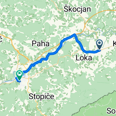
Zlatorogova transferzala ponosa Vzpon do Gospodične na Gorjancih
A cycling route starting in Šentjernej, Občina Šentjernej, Slovenia.
Overview
About this route
Štart: Brusnice pri Novem mestu
Cilj: križišče pri Krvavem kamnu
Podelitev nagrad in druženje pri planinskem domu na Gospodični.
Prireditev bo v soboto 28.maja 2011 s štartom ob 11.00 v Brusnicah.
- -:--
- Duration
- 13.5 km
- Distance
- 781 m
- Ascent
- 133 m
- Descent
- ---
- Avg. speed
- ---
- Avg. speed
Route quality
Waytypes & surfaces along the route
Waytypes
Quiet road
7.4 km
(55 %)
Road
6.1 km
(45 %)
Undefined
-0 km
(<1 %)
Surfaces
Paved
6.1 km
(45 %)
Unpaved
7.4 km
(55 %)
Asphalt
6.1 km
(45 %)
Gravel
5.8 km
(43 %)
Route highlights
Points of interest along the route
Point of interest after 5.9 km
KONEC ASFALTA
Point of interest after 11.6 km
CILJ PRIREDITVE
Continue with Bikemap
Use, edit, or download this cycling route
You would like to ride Zlatorogova transferzala ponosa Vzpon do Gospodične na Gorjancih or customize it for your own trip? Here is what you can do with this Bikemap route:
Free features
- Save this route as favorite or in collections
- Copy & plan your own version of this route
- Sync your route with Garmin or Wahoo
Premium features
Free trial for 3 days, or one-time payment. More about Bikemap Premium.
- Navigate this route on iOS & Android
- Export a GPX / KML file of this route
- Create your custom printout (try it for free)
- Download this route for offline navigation
Discover more Premium features.
Get Bikemap PremiumFrom our community
Other popular routes starting in Šentjernej
- Po Sloveniji 2009, 4.. etapa Šentjernej - Novo mesto, 153 km
- Distance
- 153.9 km
- Ascent
- 1,606 m
- Descent
- 1,605 m
- Location
- Šentjernej, Občina Šentjernej, Slovenia
- Mostovi Krke
- Distance
- 52.4 km
- Ascent
- 241 m
- Descent
- 241 m
- Location
- Šentjernej, Občina Šentjernej, Slovenia
- Zlatorogova transferzala ponosa Vzpon do Gospodične na Gorjancih
- Distance
- 13.5 km
- Ascent
- 781 m
- Descent
- 133 m
- Location
- Šentjernej, Občina Šentjernej, Slovenia
- VZPON NA JAVOROVICO
- Distance
- 7.8 km
- Ascent
- 399 m
- Descent
- 16 m
- Location
- Šentjernej, Občina Šentjernej, Slovenia
- Cerov Log-Trdinov vrh-Cerov Log (spust po Laški poti)
- Distance
- 21.3 km
- Ascent
- 918 m
- Descent
- 915 m
- Location
- Šentjernej, Občina Šentjernej, Slovenia
- MTB po Gorjancih
- Distance
- 19.1 km
- Ascent
- 707 m
- Descent
- 702 m
- Location
- Šentjernej, Občina Šentjernej, Slovenia
- Trdinov vrh - Sv. Gera
- Distance
- 41.3 km
- Ascent
- 1,137 m
- Descent
- 1,137 m
- Location
- Šentjernej, Občina Šentjernej, Slovenia
- Šentjernej-Raka-Bučka-Šmarjeta-Šentjernej
- Distance
- 47.3 km
- Ascent
- 442 m
- Descent
- 445 m
- Location
- Šentjernej, Občina Šentjernej, Slovenia
Open it in the app