

2020-21 coronavirus
Manuela 2º Circuito
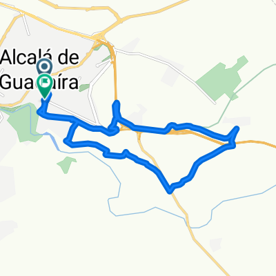
A cycling route starting in Alcalá de Guadaira, Andalusia, Spain.
Overview
About this route
- -:--
- Duration
- 14 km
- Distance
- 119 m
- Ascent
- 137 m
- Descent
- ---
- Avg. speed
- ---
- Max. altitude

Part of
2020-21 coronavirus
5 stages
Route highlights
Points of interest along the route
Point of interest after 2.8 km
Cruce SE-3203
Point of interest after 3.5 km
Paso Bajo A92
Point of interest after 7 km
Palacio Gandul
Point of interest after 7.4 km
Paso Bajo A-92
Point of interest after 9.3 km
Cruce A-360 Utrera Moron
Point of interest after 10.1 km
Castillo Marchenilla
Continue with Bikemap
Use, edit, or download this cycling route
You would like to ride Manuela 2º Circuito or customize it for your own trip? Here is what you can do with this Bikemap route:
Free features
- Save this route as favorite or in collections
- Copy & plan your own version of this route
- Sync your route with Garmin or Wahoo
Premium features
Free trial for 3 days, or one-time payment. More about Bikemap Premium.
- Navigate this route on iOS & Android
- Export a GPX / KML file of this route
- Create your custom printout (try it for free)
- Download this route for offline navigation
Discover more Premium features.
Get Bikemap PremiumFrom our community
Other popular routes starting in Alcalá de Guadaira
 Gandul
- Distance
- 20.9 km
- Ascent
- 185 m
- Descent
- 185 m
- Location
- Alcalá de Guadaira, Andalusia, Spain
 De Calle de Carmen Conde, 39, Alcalá de Guadaíra a Calle de Carmen Conde, 14, Alcalá de Guadaíra
- Distance
- 42 km
- Ascent
- 426 m
- Descent
- 430 m
- Location
- Alcalá de Guadaira, Andalusia, Spain
 Alcalá de Guadaira(inst. Albero) - Mairena del Alcor (Castillo de Mairena)
- Distance
- 15.1 km
- Ascent
- 203 m
- Descent
- 98 m
- Location
- Alcalá de Guadaira, Andalusia, Spain
 Manuela 2º Circuito
- Distance
- 14 km
- Ascent
- 119 m
- Descent
- 137 m
- Location
- Alcalá de Guadaira, Andalusia, Spain
 ALCALA-DRAGON-PARQUE CIRCULAR
- Distance
- 17 km
- Ascent
- 179 m
- Descent
- 176 m
- Location
- Alcalá de Guadaira, Andalusia, Spain
 ruta alcalareña-olavide pastor
- Distance
- 16 km
- Ascent
- 68 m
- Descent
- 131 m
- Location
- Alcalá de Guadaira, Andalusia, Spain
 Alcalá Carmona Via Verde
- Distance
- 46.3 km
- Ascent
- 177 m
- Descent
- 177 m
- Location
- Alcalá de Guadaira, Andalusia, Spain
 A2 Alcalá - Pablo de Olavide CLONED FROM ROUTE 230135
- Distance
- 10.9 km
- Ascent
- 66 m
- Descent
- 77 m
- Location
- Alcalá de Guadaira, Andalusia, Spain
Open it in the app