

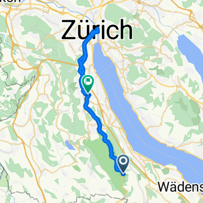
Albiskette
A cycling route starting in Horgen / Oberdorf, Canton of Zurich, Switzerland.
Overview
About this route
You are almost 'ready' for the Zimmerberg and Albis Snow Cup.
- 7 h 42 min
- Duration
- 29.5 km
- Distance
- 985 m
- Ascent
- 1,028 m
- Descent
- 3.8 km/h
- Avg. speed
- ---
- Max. altitude

Continue with Bikemap
Use, edit, or download this cycling route
You would like to ride Albiskette or customize it for your own trip? Here is what you can do with this Bikemap route:
Free features
- Save this route as favorite or in collections
- Copy & plan your own version of this route
- Sync your route with Garmin or Wahoo
Premium features
Free trial for 3 days, or one-time payment. More about Bikemap Premium.
- Navigate this route on iOS & Android
- Export a GPX / KML file of this route
- Create your custom printout (try it for free)
- Download this route for offline navigation
Discover more Premium features.
Get Bikemap PremiumFrom our community
Other popular routes starting in Horgen / Oberdorf
 VCA VCH Horgenberg
- Distance
- 2.9 km
- Ascent
- 54 m
- Descent
- 51 m
- Location
- Horgen / Oberdorf, Canton of Zurich, Switzerland
 L'Areuse–Emme–Sihl - Etappe 5
- Distance
- 28.4 km
- Ascent
- 112 m
- Descent
- 176 m
- Location
- Horgen / Oberdorf, Canton of Zurich, Switzerland
 Adliswil - Gottschalkenberg
- Distance
- 60.8 km
- Ascent
- 1,264 m
- Descent
- 1,265 m
- Location
- Horgen / Oberdorf, Canton of Zurich, Switzerland
 B - Albishorn
- Distance
- 31.1 km
- Ascent
- 845 m
- Descent
- 845 m
- Location
- Horgen / Oberdorf, Canton of Zurich, Switzerland

3122®
Horgen Oberdorf Radfahren- Distance
- 5.7 km
- Ascent
- 32 m
- Descent
- 8 m
- Location
- Horgen / Oberdorf, Canton of Zurich, Switzerland
 Seestrasse 89, Horgen nach Badenerstrasse 571, Zürich
- Distance
- 19.1 km
- Ascent
- 38 m
- Descent
- 58 m
- Location
- Horgen / Oberdorf, Canton of Zurich, Switzerland
 Tödistrasse, Horgen nach Tödistrasse, Horgen
- Distance
- 47.6 km
- Ascent
- 946 m
- Descent
- 940 m
- Location
- Horgen / Oberdorf, Canton of Zurich, Switzerland
 Horgen-Hirzel-Amden-Vorder Höhi-Schwägalp
- Distance
- 113.2 km
- Ascent
- 1,809 m
- Descent
- 1,638 m
- Location
- Horgen / Oberdorf, Canton of Zurich, Switzerland
Open it in the app