

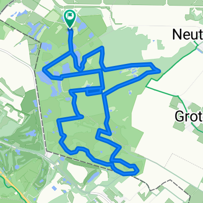
Selfkant-Runde
A cycling route starting in Gangelt, North Rhine-Westphalia, Germany.
Overview
About this route
- -:--
- Duration
- 34 km
- Distance
- 88 m
- Ascent
- 88 m
- Descent
- ---
- Avg. speed
- ---
- Max. altitude

Route quality
Waytypes & surfaces along the route
Waytypes
Quiet road
15 km
(44 %)
Track
11.6 km
(34 %)
Surfaces
Paved
28.9 km
(85 %)
Unpaved
0.3 km
(1 %)
Asphalt
26.9 km
(79 %)
Paved (undefined)
2 km
(6 %)
Continue with Bikemap
Use, edit, or download this cycling route
You would like to ride Selfkant-Runde or customize it for your own trip? Here is what you can do with this Bikemap route:
Free features
- Save this route as favorite or in collections
- Copy & plan your own version of this route
- Sync your route with Garmin or Wahoo
Premium features
Free trial for 3 days, or one-time payment. More about Bikemap Premium.
- Navigate this route on iOS & Android
- Export a GPX / KML file of this route
- Create your custom printout (try it for free)
- Download this route for offline navigation
Discover more Premium features.
Get Bikemap PremiumFrom our community
Other popular routes starting in Gangelt
 Heidenaturpark-Route (Gangelt)
- Distance
- 39.4 km
- Ascent
- 201 m
- Descent
- 201 m
- Location
- Gangelt, North Rhine-Westphalia, Germany
 Tryout Santiago 254 KM
- Distance
- 253.9 km
- Ascent
- 3,574 m
- Descent
- 3,573 m
- Location
- Gangelt, North Rhine-Westphalia, Germany
 Hohenbusch naar Hohenbusch
- Distance
- 14.1 km
- Ascent
- 89 m
- Descent
- 140 m
- Location
- Gangelt, North Rhine-Westphalia, Germany
 Gangelt - Zulpich
- Distance
- 71.3 km
- Ascent
- 363 m
- Descent
- 249 m
- Location
- Gangelt, North Rhine-Westphalia, Germany
 10,8 Km Heringsbosch
- Distance
- 10.8 km
- Ascent
- 72 m
- Descent
- 74 m
- Location
- Gangelt, North Rhine-Westphalia, Germany
 Wildparktour
- Distance
- 27 km
- Ascent
- 98 m
- Descent
- 99 m
- Location
- Gangelt, North Rhine-Westphalia, Germany
 jabeek schinveld schaesberg hoensbroek puth doenrade jabeek 36 km
- Distance
- 35.2 km
- Ascent
- 247 m
- Descent
- 241 m
- Location
- Gangelt, North Rhine-Westphalia, Germany
 Heidenaturpark
- Distance
- 28.7 km
- Ascent
- 184 m
- Descent
- 182 m
- Location
- Gangelt, North Rhine-Westphalia, Germany
Open it in the app