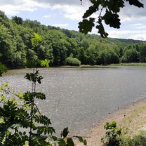
Sonntags zur Ahr uz
A cycling route starting in Rheinbach, North Rhine-Westphalia, Germany.
Overview
About this route
- -:--
- Duration
- 89.2 km
- Distance
- 966 m
- Ascent
- 963 m
- Descent
- ---
- Avg. speed
- ---
- Avg. speed
Route quality
Waytypes & surfaces along the route
Waytypes
Undefined
89.2 km
(100 %)
Surfaces
Undefined
89.2 km
(100 %)
Continue with Bikemap
Use, edit, or download this cycling route
You would like to ride Sonntags zur Ahr uz or customize it for your own trip? Here is what you can do with this Bikemap route:
Free features
- Save this route as favorite or in collections
- Copy & plan your own version of this route
- Sync your route with Garmin or Wahoo
Premium features
Free trial for 3 days, or one-time payment. More about Bikemap Premium.
- Navigate this route on iOS & Android
- Export a GPX / KML file of this route
- Create your custom printout (try it for free)
- Download this route for offline navigation
Discover more Premium features.
Get Bikemap PremiumFrom our community
Other popular routes starting in Rheinbach
- Trip nach Altenahr
- Distance
- 31.9 km
- Ascent
- 598 m
- Descent
- 484 m
- Location
- Rheinbach, North Rhine-Westphalia, Germany
- Vischeltal, Ahrtal
- Distance
- 60.4 km
- Ascent
- 857 m
- Descent
- 883 m
- Location
- Rheinbach, North Rhine-Westphalia, Germany
- Brühl Retour 56 KM
- Distance
- 55.7 km
- Ascent
- 203 m
- Descent
- 204 m
- Location
- Rheinbach, North Rhine-Westphalia, Germany
- Sonntags zur Ahr uz
- Distance
- 89.2 km
- Ascent
- 966 m
- Descent
- 963 m
- Location
- Rheinbach, North Rhine-Westphalia, Germany
- Waldkapelle-Binzenbach-Kreuzberg-Hilberath
- Distance
- 43.2 km
- Ascent
- 576 m
- Descent
- 576 m
- Location
- Rheinbach, North Rhine-Westphalia, Germany
- Eifel Große Runde
- Distance
- 61.2 km
- Ascent
- 517 m
- Descent
- 570 m
- Location
- Rheinbach, North Rhine-Westphalia, Germany
- Waldkapelle-Tomburg-Wald-Decke Tönnes-BM-Steinbach-Waldkapelle
- Distance
- 51.8 km
- Ascent
- 577 m
- Descent
- 577 m
- Location
- Rheinbach, North Rhine-Westphalia, Germany
- Leichte Rundfahrt nördlich von Rheinbach
- Distance
- 15.7 km
- Ascent
- 37 m
- Descent
- 37 m
- Location
- Rheinbach, North Rhine-Westphalia, Germany