

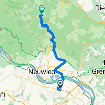
Im Schützengrund 54, Neuwied nach Im Schützengrund 54, Neuwied
A cycling route starting in Urmitz, Rhineland-Palatinate, Germany.
Overview
About this route
- 3 h 14 min
- Duration
- 17.2 km
- Distance
- 333 m
- Ascent
- 330 m
- Descent
- 5.3 km/h
- Avg. speed
- ---
- Max. altitude

Route photos


Route quality
Waytypes & surfaces along the route
Waytypes
Path
4.6 km
(27 %)
Quiet road
3.3 km
(19 %)
Surfaces
Paved
8.4 km
(49 %)
Unpaved
3.3 km
(19 %)
Asphalt
6 km
(35 %)
Gravel
2.4 km
(14 %)
Continue with Bikemap
Use, edit, or download this cycling route
You would like to ride Im Schützengrund 54, Neuwied nach Im Schützengrund 54, Neuwied or customize it for your own trip? Here is what you can do with this Bikemap route:
Free features
- Save this route as favorite or in collections
- Copy & plan your own version of this route
- Sync your route with Garmin or Wahoo
Premium features
Free trial for 3 days, or one-time payment. More about Bikemap Premium.
- Navigate this route on iOS & Android
- Export a GPX / KML file of this route
- Create your custom printout (try it for free)
- Download this route for offline navigation
Discover more Premium features.
Get Bikemap PremiumFrom our community
Other popular routes starting in Urmitz
 Urmitz Radfahren
- Distance
- 33.5 km
- Ascent
- 52 m
- Descent
- 71 m
- Location
- Urmitz, Rhineland-Palatinate, Germany
 Rheinau 17, Mülheim-Kärlich nach Koblenz
- Distance
- 14.5 km
- Ascent
- 41 m
- Descent
- 37 m
- Location
- Urmitz, Rhineland-Palatinate, Germany
 75 km Urmitz - Mayen - Brohltal runter - Rhein
- Distance
- 73.6 km
- Ascent
- 545 m
- Descent
- 545 m
- Location
- Urmitz, Rhineland-Palatinate, Germany
 Münstermaifeld via Schrumpftal
- Distance
- 40.8 km
- Ascent
- 300 m
- Descent
- 100 m
- Location
- Urmitz, Rhineland-Palatinate, Germany
 Urmitz - Kurtscheid via Ehlscheid
- Distance
- 23.8 km
- Ascent
- 422 m
- Descent
- 106 m
- Location
- Urmitz, Rhineland-Palatinate, Germany
 Rheintour mit Abwegen
- Distance
- 38.3 km
- Ascent
- 864 m
- Descent
- 868 m
- Location
- Urmitz, Rhineland-Palatinate, Germany
 Maifeld-Radweg - Vulkanpark-Radweg von Urmitz
- Distance
- 63.4 km
- Ascent
- 535 m
- Descent
- 533 m
- Location
- Urmitz, Rhineland-Palatinate, Germany
 Im Schützengrund 54, Neuwied nach Im Schützengrund 54, Neuwied
- Distance
- 17.2 km
- Ascent
- 333 m
- Descent
- 330 m
- Location
- Urmitz, Rhineland-Palatinate, Germany
Open it in the app