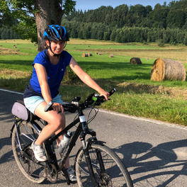
Szlak Turonia - żółty szlak dookoła Wrocławia
A cycling route starting in Bielany Wrocławskie, Lower Silesian Voivodeship, Poland.
Overview
About this route
The yellow hiking trail around Wrocław. Partially asphalted on low-traffic roads, partially in forests and fields.
Read the trail description at <a href="https://majatravels.com/pl/szlak-turonia-rowerem-wokol-wroclawia/">majatravels.com</a>.
- -:--
- Duration
- 188.2 km
- Distance
- 555 m
- Ascent
- 554 m
- Descent
- ---
- Avg. speed
- ---
- Max. altitude
Route photos
Route quality
Waytypes & surfaces along the route
Waytypes
Track
71.5 km
(38 %)
Quiet road
43.3 km
(23 %)
Surfaces
Paved
84.7 km
(45 %)
Unpaved
62.1 km
(33 %)
Asphalt
77.2 km
(41 %)
Ground
24.5 km
(13 %)
Continue with Bikemap
Use, edit, or download this cycling route
You would like to ride Szlak Turonia - żółty szlak dookoła Wrocławia or customize it for your own trip? Here is what you can do with this Bikemap route:
Free features
- Save this route as favorite or in collections
- Copy & plan your own version of this route
- Split it into stages to create a multi-day tour
- Sync your route with Garmin or Wahoo
Premium features
Free trial for 3 days, or one-time payment. More about Bikemap Premium.
- Navigate this route on iOS & Android
- Export a GPX / KML file of this route
- Create your custom printout (try it for free)
- Download this route for offline navigation
Discover more Premium features.
Get Bikemap PremiumFrom our community
Other popular routes starting in Bielany Wrocławskie
 Z Krzyków na wyspę
- Distance
- 30 km
- Ascent
- 49 m
- Descent
- 45 m
- Location
- Bielany Wrocławskie, Lower Silesian Voivodeship, Poland
 Świdnicka, Wrocław do Magnoliowa 27, Bielany Wrocławskie
- Distance
- 43.6 km
- Ascent
- 54 m
- Descent
- 55 m
- Location
- Bielany Wrocławskie, Lower Silesian Voivodeship, Poland
 Day 3
Day 3- Distance
- 65.8 km
- Ascent
- 333 m
- Descent
- 110 m
- Location
- Bielany Wrocławskie, Lower Silesian Voivodeship, Poland
 Wrocław pętla
- Distance
- 65.5 km
- Ascent
- 69 m
- Descent
- 72 m
- Location
- Bielany Wrocławskie, Lower Silesian Voivodeship, Poland
 Klecina - Kobierzyce
- Distance
- 13 km
- Ascent
- 39 m
- Descent
- 25 m
- Location
- Bielany Wrocławskie, Lower Silesian Voivodeship, Poland
 Szlak Turonia - żółty szlak dookoła Wrocławia
- Distance
- 188.2 km
- Ascent
- 555 m
- Descent
- 554 m
- Location
- Bielany Wrocławskie, Lower Silesian Voivodeship, Poland
 1b sobótka
- Distance
- 45.6 km
- Ascent
- 110 m
- Descent
- 51 m
- Location
- Bielany Wrocławskie, Lower Silesian Voivodeship, Poland
 Zabrodzka, Wrocław to Zabrodzka, Wrocław
- Distance
- 42.8 km
- Ascent
- 93 m
- Descent
- 103 m
- Location
- Bielany Wrocławskie, Lower Silesian Voivodeship, Poland
Open it in the app


