

oberbergisches - bergisches - l'town
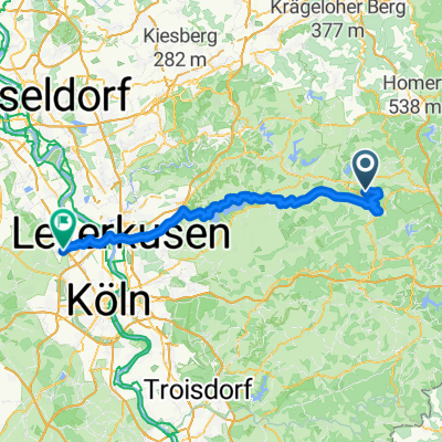
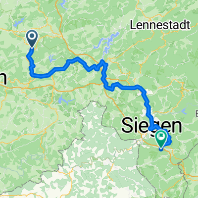
A cycling route starting in Marienheide, North Rhine-Westphalia, Germany.
Overview
About this route
short, steep climbs and wonderful, long descents characterize this route.
- -:--
- Duration
- 68 km
- Distance
- 694 m
- Ascent
- 891 m
- Descent
- ---
- Avg. speed
- 440 m
- Max. altitude
Route quality
Waytypes & surfaces along the route
Waytypes
Road
21.8 km
(32 %)
Quiet road
10.9 km
(16 %)
Surfaces
Paved
54.4 km
(80 %)
Unpaved
2 km
(3 %)
Asphalt
53.7 km
(79 %)
Ground
1.4 km
(2 %)
Continue with Bikemap
Use, edit, or download this cycling route
You would like to ride oberbergisches - bergisches - l'town or customize it for your own trip? Here is what you can do with this Bikemap route:
Free features
- Save this route as favorite or in collections
- Copy & plan your own version of this route
- Sync your route with Garmin or Wahoo
Premium features
Free trial for 3 days, or one-time payment. More about Bikemap Premium.
- Navigate this route on iOS & Android
- Export a GPX / KML file of this route
- Create your custom printout (try it for free)
- Download this route for offline navigation
Discover more Premium features.
Get Bikemap PremiumFrom our community
Other popular routes starting in Marienheide
 Route in Marienheide
- Distance
- 74.2 km
- Ascent
- 1,101 m
- Descent
- 1,401 m
- Location
- Marienheide, North Rhine-Westphalia, Germany
 Rententour - Marienheide - Wilnsdorf
- Distance
- 86.7 km
- Ascent
- 1,141 m
- Descent
- 1,246 m
- Location
- Marienheide, North Rhine-Westphalia, Germany
 Winkel - Kerspetalsperre - Kierspe - Winkel
- Distance
- 38.2 km
- Ascent
- 690 m
- Descent
- 692 m
- Location
- Marienheide, North Rhine-Westphalia, Germany
 Winkel - Versetalsperre - Winkel
- Distance
- 65.1 km
- Ascent
- 1,274 m
- Descent
- 1,275 m
- Location
- Marienheide, North Rhine-Westphalia, Germany
 Rund Rönsahl
- Distance
- 42.8 km
- Ascent
- 700 m
- Descent
- 700 m
- Location
- Marienheide, North Rhine-Westphalia, Germany
 Bahntrassen im Bergischen
- Distance
- 54.8 km
- Ascent
- 238 m
- Descent
- 490 m
- Location
- Marienheide, North Rhine-Westphalia, Germany
 oberbergisches - bergisches - l'town
- Distance
- 68 km
- Ascent
- 694 m
- Descent
- 891 m
- Location
- Marienheide, North Rhine-Westphalia, Germany
 Bergischer-Panorama Radweg
- Distance
- 63.6 km
- Ascent
- 132 m
- Descent
- 436 m
- Location
- Marienheide, North Rhine-Westphalia, Germany
Open it in the app