

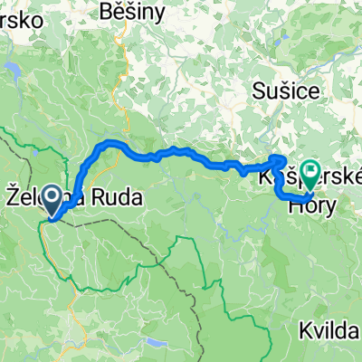
Špičák - Klatovy 6
A cycling route starting in Železná Ruda, Plzeň Region, Czechia.
Overview
About this route
The bus with trailer departs from Klatovy bus station at 7:55 AM -Shpičák -on the road towards Klatovy, after about 300m turn left towards Hamry CT33 -at the dam keep on CT33, direction Nýrsko -Bystřice -Úborsko -Janovice -Bezděkov -Tajanov -Klatovy
- -:--
- Duration
- 41.3 km
- Distance
- 115 m
- Ascent
- 697 m
- Descent
- ---
- Avg. speed
- ---
- Max. altitude
Continue with Bikemap
Use, edit, or download this cycling route
You would like to ride Špičák - Klatovy 6 or customize it for your own trip? Here is what you can do with this Bikemap route:
Free features
- Save this route as favorite or in collections
- Copy & plan your own version of this route
- Sync your route with Garmin or Wahoo
Premium features
Free trial for 3 days, or one-time payment. More about Bikemap Premium.
- Navigate this route on iOS & Android
- Export a GPX / KML file of this route
- Create your custom printout (try it for free)
- Download this route for offline navigation
Discover more Premium features.
Get Bikemap PremiumFrom our community
Other popular routes starting in Železná Ruda
 Von Bayerisch Eisenstein bis Nová Pec
- Distance
- 181.1 km
- Ascent
- 4,281 m
- Descent
- 4,269 m
- Location
- Železná Ruda, Plzeň Region, Czechia
 Vrcholky Zeleznorudska
- Distance
- 76.4 km
- Ascent
- 2,040 m
- Descent
- 2,040 m
- Location
- Železná Ruda, Plzeň Region, Czechia
 Dunaj 2008 - 1. deň
- Distance
- 94 km
- Ascent
- 599 m
- Descent
- 1,072 m
- Location
- Železná Ruda, Plzeň Region, Czechia
 Unbenannte Route
- Distance
- 41 km
- Ascent
- 1,117 m
- Descent
- 1,103 m
- Location
- Železná Ruda, Plzeň Region, Czechia
 16. Ein Hauch von Taiga - Der Nationalpark Radweg
- Distance
- 149.4 km
- Ascent
- 1,955 m
- Descent
- 1,962 m
- Location
- Železná Ruda, Plzeň Region, Czechia
 Mauth - Markt Eisenstein
- Distance
- 66.1 km
- Ascent
- 1,522 m
- Descent
- 1,518 m
- Location
- Železná Ruda, Plzeň Region, Czechia
 Bayerisch Eisenstein nach Fügnerova, Kašperské Hory
- Distance
- 41.3 km
- Ascent
- 1,126 m
- Descent
- 1,103 m
- Location
- Železná Ruda, Plzeň Region, Czechia
 viden
viden- Distance
- 542.3 km
- Ascent
- 909 m
- Descent
- 1,506 m
- Location
- Železná Ruda, Plzeň Region, Czechia
Open it in the app