

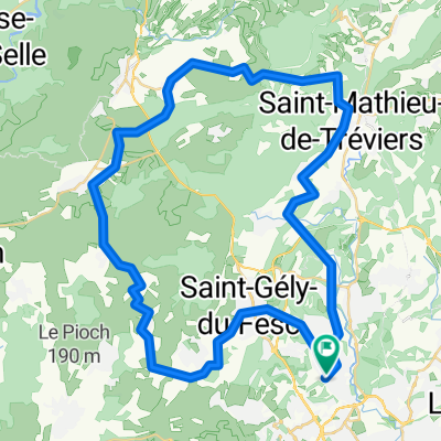
Samedi "Je te donne ma lumière"
A cycling route starting in Montferrier-sur-Lez, Occitanie, France.
Overview
About this route
- 3 h 42 min
- Duration
- 62.1 km
- Distance
- 732 m
- Ascent
- 726 m
- Descent
- 16.8 km/h
- Avg. speed
- ---
- Max. altitude

Route quality
Waytypes & surfaces along the route
Waytypes
Road
31 km
(50 %)
Quiet road
19.9 km
(32 %)
Surfaces
Paved
15.5 km
(25 %)
Unpaved
0.6 km
(1 %)
Asphalt
14.9 km
(24 %)
Paved (undefined)
0.6 km
(1 %)
Continue with Bikemap
Use, edit, or download this cycling route
You would like to ride Samedi "Je te donne ma lumière" or customize it for your own trip? Here is what you can do with this Bikemap route:
Free features
- Save this route as favorite or in collections
- Copy & plan your own version of this route
- Sync your route with Garmin or Wahoo
Premium features
Free trial for 3 days, or one-time payment. More about Bikemap Premium.
- Navigate this route on iOS & Android
- Export a GPX / KML file of this route
- Create your custom printout (try it for free)
- Download this route for offline navigation
Discover more Premium features.
Get Bikemap PremiumFrom our community
Other popular routes starting in Montferrier-sur-Lez
 1st Montpellier tour
- Distance
- 49.6 km
- Ascent
- 345 m
- Descent
- 350 m
- Location
- Montferrier-sur-Lez, Occitanie, France
 Circuit un peu endurant......
- Distance
- 141.4 km
- Ascent
- 797 m
- Descent
- 797 m
- Location
- Montferrier-sur-Lez, Occitanie, France
 Montpellier-Salagou
- Distance
- 11.8 km
- Ascent
- 53 m
- Descent
- 140 m
- Location
- Montferrier-sur-Lez, Occitanie, France
 fdsfs
fdsfs- Distance
- 103.5 km
- Ascent
- 1,125 m
- Descent
- 1,132 m
- Location
- Montferrier-sur-Lez, Occitanie, France
 vers Mazamet
- Distance
- 222.4 km
- Ascent
- 2,358 m
- Descent
- 2,132 m
- Location
- Montferrier-sur-Lez, Occitanie, France
 MUC_Balade Montferrier-sur-Lez, St-Mathieu-de-Tréviers, St-Bauzille-de-Montmel
- Distance
- 47 km
- Ascent
- 271 m
- Descent
- 271 m
- Location
- Montferrier-sur-Lez, Occitanie, France
 tour pic st loup
- Distance
- 62.9 km
- Ascent
- 474 m
- Descent
- 471 m
- Location
- Montferrier-sur-Lez, Occitanie, France
 sortie 30 mars aqueduccyclos
- Distance
- 118.1 km
- Ascent
- 735 m
- Descent
- 734 m
- Location
- Montferrier-sur-Lez, Occitanie, France
Open it in the app