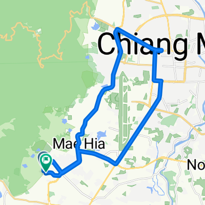
ถนนเลี่ยงเมืองสันป่าตองหางดง, Tambon Hang Dong to NaTeaTime Tambon Nong Tong
A cycling route starting in Hang Dong, Chiang Mai Province, Thailand.
Overview
About this route
- 1 h 4 min
- Duration
- 17.5 km
- Distance
- 177 m
- Ascent
- 208 m
- Descent
- 16.4 km/h
- Avg. speed
- ---
- Avg. speed
Route quality
Waytypes & surfaces along the route
Waytypes
Quiet road
11.1 km
(63 %)
Road
4 km
(23 %)
Surfaces
Paved
13.5 km
(77 %)
Unpaved
0.7 km
(4 %)
Paved (undefined)
6.6 km
(37 %)
Asphalt
3.7 km
(21 %)
Continue with Bikemap
Use, edit, or download this cycling route
You would like to ride ถนนเลี่ยงเมืองสันป่าตองหางดง, Tambon Hang Dong to NaTeaTime Tambon Nong Tong or customize it for your own trip? Here is what you can do with this Bikemap route:
Free features
- Save this route as favorite or in collections
- Copy & plan your own version of this route
- Sync your route with Garmin or Wahoo
Premium features
Free trial for 3 days, or one-time payment. More about Bikemap Premium.
- Navigate this route on iOS & Android
- Export a GPX / KML file of this route
- Create your custom printout (try it for free)
- Download this route for offline navigation
Discover more Premium features.
Get Bikemap PremiumFrom our community
Other popular routes starting in Hang Dong
- beautiful mountainous bike with one steep hill
- Distance
- 13 km
- Ascent
- 125 m
- Descent
- 124 m
- Location
- Hang Dong, Chiang Mai Province, Thailand
- Thailand, Tambon Nong Kwai naar PWH5+G9R, Nong Kwai
- Distance
- 19.1 km
- Ascent
- 195 m
- Descent
- 188 m
- Location
- Hang Dong, Chiang Mai Province, Thailand
- Tambon Nam Phrae naar Tambon Nam Phrae
- Distance
- 16 km
- Ascent
- 188 m
- Descent
- 179 m
- Location
- Hang Dong, Chiang Mai Province, Thailand
- Nice short ride
- Distance
- 19.7 km
- Ascent
- 265 m
- Descent
- 265 m
- Location
- Hang Dong, Chiang Mai Province, Thailand
- Hang Dong Coffee Ride
- Distance
- 61.2 km
- Ascent
- 46 m
- Descent
- 49 m
- Location
- Hang Dong, Chiang Mai Province, Thailand
- ถนนเลี่ยงเมืองสันป่าตองหางดง, Tambon Hang Dong to NaTeaTime Tambon Nong Tong
- Distance
- 17.5 km
- Ascent
- 177 m
- Descent
- 208 m
- Location
- Hang Dong, Chiang Mai Province, Thailand
- great for sunset!
- Distance
- 15.1 km
- Ascent
- 191 m
- Descent
- 192 m
- Location
- Hang Dong, Chiang Mai Province, Thailand
- Soi Mu Ban Wiphani View 73, Tambon Ban Waen to Soi Mu Ban Wiphani View 73, Tambon Ban Waen
- Distance
- 8.2 km
- Ascent
- 69 m
- Descent
- 74 m
- Location
- Hang Dong, Chiang Mai Province, Thailand