

Po regionalnych zalewach i stawach
A cycling route starting in Radzionków, Silesian Voivodeship, Poland.
Overview
About this route
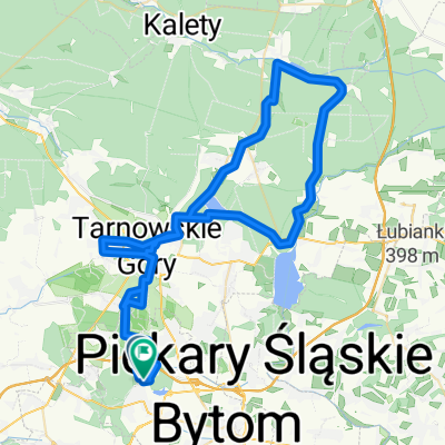
Start and stop loop at the parking lot by M1 Bytom
Route: Bytom M1 -> Radzionków Rojca -> Radzionków -> Piekary Śląskie -> Świerklaniec -> Nowe Chechło -> Nakło Śląskie -> Bobrowniki Śląskie -> Bytom Sucha Góra -> Bytom M1
Interesting places on the route: Silesian Botanical Garden, Liberation Mound, MOSiR Piekary Śląskie, Cegielnia Pond, (Rogoźnik Reservoir - option), Świerklaniec Lake, Park in Świerklańc, ponds under Żyglinkiem, Chechło-Nakło reservoir with a cyclist's bar at Adik, Church and mausoleum of the Donnersmarcks in Nakło Śląskie, Park in Nakło Śląskie with the Palace - Silesian Cultural Center, Grota Park in Suchej Góra.
Option to extend the route to Rogoźnik +14km
- -:--
- Duration
- 37.1 km
- Distance
- 185 m
- Ascent
- 185 m
- Descent
- ---
- Avg. speed
- ---
- Max. altitude

Route quality
Waytypes & surfaces along the route
Waytypes
Track
12.6 km
(34 %)
Quiet road
9.3 km
(25 %)
Surfaces
Paved
14.1 km
(38 %)
Unpaved
15.6 km
(42 %)
Asphalt
10.4 km
(28 %)
Gravel
10 km
(27 %)
Route highlights
Points of interest along the route
Point of interest after 4.2 km
MOSiR Radzionków
Point of interest after 4.5 km
Śląski Ogród Botaniczny w Radzionkowie
Point of interest after 5.9 km
Kopiec Wyzwolenia w Piekarach Śląskich
Point of interest after 8.4 km
MOSiR Piekary Śląskie
Point of interest after 10.1 km
Staw Cegielnia
Point of interest after 11.6 km
Rozszerzenie trasy +10km Droga nad zalew Rogoźnik
Point of interest after 11.7 km
Jezioro w Świerklańcu
Point of interest after 13.6 km
Park w Świerklańcu
Point of interest after 20.1 km
Stawiki przy Żyglinku
Point of interest after 22.1 km
Zalew Chechło-Nakło
Point of interest after 24.5 km
Bar u Adika dla rowerzystów :)
Point of interest after 28.3 km
Kościół i mauzoleum Donnersmarcków w Nakle Śląskim
Point of interest after 28.6 km
Park w Nakle Śląskim z Pałacem - Centrum Kultury Śląskiej
Point of interest after 29.3 km
Przejazd kolejowy "na dzwonek" :)
Point of interest after 32.9 km
Zespół Przyrodniczo-Krajobrazowy
Point of interest after 33.5 km
Park Grota w Suchej Górze
Continue with Bikemap
Use, edit, or download this cycling route
You would like to ride Po regionalnych zalewach i stawach or customize it for your own trip? Here is what you can do with this Bikemap route:
Free features
- Save this route as favorite or in collections
- Copy & plan your own version of this route
- Sync your route with Garmin or Wahoo
Premium features
Free trial for 3 days, or one-time payment. More about Bikemap Premium.
- Navigate this route on iOS & Android
- Export a GPX / KML file of this route
- Create your custom printout (try it for free)
- Download this route for offline navigation
Discover more Premium features.
Get Bikemap PremiumFrom our community
Other popular routes starting in Radzionków
 Biały Śląsk. Przez lasy lublinieckie
- Distance
- 86.2 km
- Ascent
- 574 m
- Descent
- 574 m
- Location
- Radzionków, Silesian Voivodeship, Poland
 W lublinieckie lasy - podróż sentymentalna
- Distance
- 98.7 km
- Ascent
- 717 m
- Descent
- 715 m
- Location
- Radzionków, Silesian Voivodeship, Poland
 Route in Bytom
- Distance
- 73.5 km
- Ascent
- 366 m
- Descent
- 368 m
- Location
- Radzionków, Silesian Voivodeship, Poland
 Z synem najlepiej :)
- Distance
- 12.2 km
- Ascent
- 95 m
- Descent
- 98 m
- Location
- Radzionków, Silesian Voivodeship, Poland
 Po regionalnych zalewach i stawach
- Distance
- 37.1 km
- Ascent
- 185 m
- Descent
- 185 m
- Location
- Radzionków, Silesian Voivodeship, Poland
 Miechowice - Zbrosławice Bunkier 31.05.2012
- Distance
- 29 km
- Ascent
- 181 m
- Descent
- 182 m
- Location
- Radzionków, Silesian Voivodeship, Poland
 Historycznie po północnych obrzeżach GOP
- Distance
- 84.5 km
- Ascent
- 525 m
- Descent
- 523 m
- Location
- Radzionków, Silesian Voivodeship, Poland
 Lubliniec 2019 dzień 2
- Distance
- 99 km
- Ascent
- 199 m
- Descent
- 236 m
- Location
- Radzionków, Silesian Voivodeship, Poland
Open it in the app