

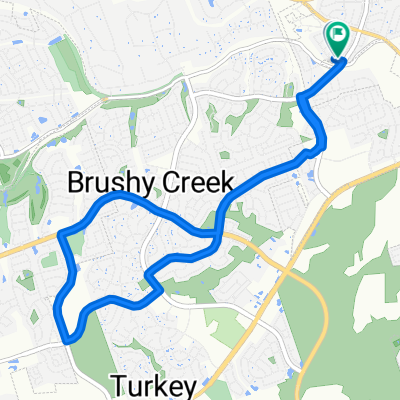
2111 Sam Bass Rd, Round Rock to 1741 Horseshoe Cir, Round Rock
A cycling route starting in Brushy Creek, Texas, United States.
Overview
About this route
- 3 min
- Duration
- 59 km
- Distance
- 0 m
- Ascent
- 0 m
- Descent
- 1,141.2 km/h
- Avg. speed
- ---
- Max. altitude
Route quality
Waytypes & surfaces along the route
Waytypes
Access road
59 km
(100 %)
Continue with Bikemap
Use, edit, or download this cycling route
You would like to ride 2111 Sam Bass Rd, Round Rock to 1741 Horseshoe Cir, Round Rock or customize it for your own trip? Here is what you can do with this Bikemap route:
Free features
- Save this route as favorite or in collections
- Copy & plan your own version of this route
- Sync your route with Garmin or Wahoo
Premium features
Free trial for 3 days, or one-time payment. More about Bikemap Premium.
- Navigate this route on iOS & Android
- Export a GPX / KML file of this route
- Create your custom printout (try it for free)
- Download this route for offline navigation
Discover more Premium features.
Get Bikemap PremiumFrom our community
Other popular routes starting in Brushy Creek
 Relaxed route in Austin
- Distance
- 24.3 km
- Ascent
- 127 m
- Descent
- 125 m
- Location
- Brushy Creek, Texas, United States
 Cedar Park, TX to Kingsland, TX
- Distance
- 110 km
- Ascent
- 378 m
- Descent
- 374 m
- Location
- Brushy Creek, Texas, United States
 2310 Brushy Creek Rd, Cedar Park to 12138 N Lamar Blvd, Austin
- Distance
- 47.5 km
- Ascent
- 182 m
- Descent
- 235 m
- Location
- Brushy Creek, Texas, United States
 2111 Sam Bass Rd, Round Rock to 1741 Horseshoe Cir, Round Rock
- Distance
- 59 km
- Ascent
- 0 m
- Descent
- 0 m
- Location
- Brushy Creek, Texas, United States
 Trek Parmer Pedaler's Ride
- Distance
- 44.6 km
- Ascent
- 252 m
- Descent
- 255 m
- Location
- Brushy Creek, Texas, United States
 Zimmerman Ln, Round Rock to Zimmerman Ln, Round Rock
- Distance
- 14 km
- Ascent
- 85 m
- Descent
- 96 m
- Location
- Brushy Creek, Texas, United States
 Cedar Park to Cedar Park
- Distance
- 29.4 km
- Ascent
- 370 m
- Descent
- 371 m
- Location
- Brushy Creek, Texas, United States
 Biking Group Main Route
- Distance
- 21 km
- Ascent
- 116 m
- Descent
- 95 m
- Location
- Brushy Creek, Texas, United States
Open it in the app