

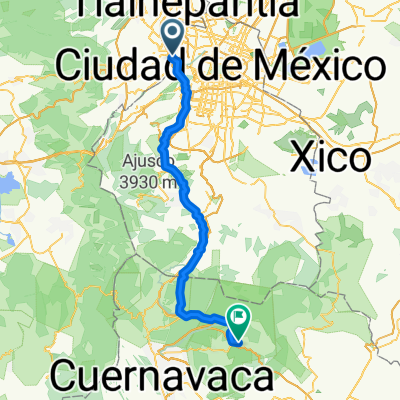
Ruta para Naye
A cycling route starting in Miguel Hidalgo, Mexico City, Mexico.
Overview
About this route
- -:--
- Duration
- 16.6 km
- Distance
- 76 m
- Ascent
- 120 m
- Descent
- ---
- Avg. speed
- ---
- Max. altitude

Route quality
Waytypes & surfaces along the route
Waytypes
Cycleway
3.3 km
(20 %)
Road
2.5 km
(15 %)
Surfaces
Paved
14.5 km
(87 %)
Unpaved
0.8 km
(5 %)
Asphalt
13.5 km
(81 %)
Concrete
1 km
(6 %)
Route highlights
Points of interest along the route

Point of interest after 8.6 km

Point of interest after 13.5 km
Recuerda ir por abajo
Continue with Bikemap
Use, edit, or download this cycling route
You would like to ride Ruta para Naye or customize it for your own trip? Here is what you can do with this Bikemap route:
Free features
- Save this route as favorite or in collections
- Copy & plan your own version of this route
- Sync your route with Garmin or Wahoo
Premium features
Free trial for 3 days, or one-time payment. More about Bikemap Premium.
- Navigate this route on iOS & Android
- Export a GPX / KML file of this route
- Create your custom printout (try it for free)
- Download this route for offline navigation
Discover more Premium features.
Get Bikemap PremiumFrom our community
Other popular routes starting in Miguel Hidalgo
 Manuel Avila Camacho 40, Miguel Hidalgo a Calle Buen Tono 26A, Cuauhtémoc
- Distance
- 13.2 km
- Ascent
- 2,353 m
- Descent
- 2,402 m
- Location
- Miguel Hidalgo, Mexico City, Mexico
 Carso - Maisson
- Distance
- 14.7 km
- Ascent
- 157 m
- Descent
- 92 m
- Location
- Miguel Hidalgo, Mexico City, Mexico
 CARGANDO GAS RETO DE EQUIPO
- Distance
- 47.4 km
- Ascent
- ---
- Descent
- ---
- Location
- Miguel Hidalgo, Mexico City, Mexico
 Tepoztlán
- Distance
- 78.8 km
- Ascent
- 1,133 m
- Descent
- 1,700 m
- Location
- Miguel Hidalgo, Mexico City, Mexico
 Taller
- Distance
- 16 km
- Ascent
- 158 m
- Descent
- 158 m
- Location
- Miguel Hidalgo, Mexico City, Mexico
 Recovered Route
- Distance
- 17.7 km
- Ascent
- 481 m
- Descent
- 441 m
- Location
- Miguel Hidalgo, Mexico City, Mexico
 Steady ride in Mexico City
- Distance
- 6.4 km
- Ascent
- 257 m
- Descent
- 54 m
- Location
- Miguel Hidalgo, Mexico City, Mexico
 tepoz
tepoz- Distance
- 85 km
- Ascent
- 1,121 m
- Descent
- 1,681 m
- Location
- Miguel Hidalgo, Mexico City, Mexico
Open it in the app