

RTI Shore Loop
A cycling route starting in Singapore, Central Singapore Community Development Council, Singapore.
Overview
About this route
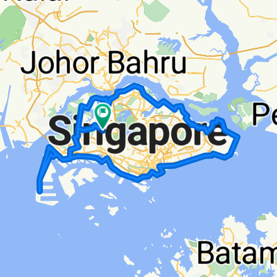
130km of fun and sweat and the smell of sea....
- -:--
- Duration
- 132 km
- Distance
- 635 m
- Ascent
- 642 m
- Descent
- ---
- Avg. speed
- ---
- Max. altitude

Route photos

Route highlights
Points of interest along the route
Accommodation after 8.7 km
Photo after 9 km
Beautiful JB View
Accommodation after 9.5 km
Accommodation after 10.7 km
Accommodation after 26 km
Bike service after 26 km
Photo after 38.3 km
Pandan Reservoir
Accommodation after 42.5 km
Accommodation after 48.5 km
Point of interest after 49.5 km
Fleet view
Photo after 50.1 km
My WorkPlace
Photo after 50.4 km
Sentosa Boardwalk
Photo after 58.1 km
Marina Barrage
Accommodation after 60 km
Drinking water after 62.6 km
Accommodation after 63.2 km
Photo after 64.3 km
East Coast Park
Accommodation after 64.6 km
Drinking water after 66.1 km
Accommodation after 66.6 km
Bike service after 66.8 km
Accommodation after 67.4 km
Accommodation after 68.3 km
Drinking water after 68.5 km
Accommodation after 68.9 km
Drinking water after 86.5 km
Accommodation after 86.6 km
Accommodation after 89.3 km
Point of interest after 89.5 km
Lunch, Rest.
Point of interest after 89.7 km
Bike Shop.
Drinking water after 96 km
Accommodation after 96.1 km
Accommodation after 97.6 km
Point of interest after 100.4 km
Coney Island entrance
Accommodation after 100.7 km
Bike service after 101.6 km
Point of interest after 102.6 km
Coney Island Exit
Accommodation after 103.1 km
Bike service after 120.4 km
Accommodation after 122.3 km
Accommodation after 124.4 km
Continue with Bikemap
Use, edit, or download this cycling route
You would like to ride RTI Shore Loop or customize it for your own trip? Here is what you can do with this Bikemap route:
Free features
- Save this route as favorite or in collections
- Copy & plan your own version of this route
- Split it into stages to create a multi-day tour
- Sync your route with Garmin or Wahoo
Premium features
Free trial for 3 days, or one-time payment. More about Bikemap Premium.
- Navigate this route on iOS & Android
- Export a GPX / KML file of this route
- Create your custom printout (try it for free)
- Download this route for offline navigation
Discover more Premium features.
Get Bikemap PremiumFrom our community
Other popular routes starting in Singapore
 First Round Island for 2021
- Distance
- 122.5 km
- Ascent
- 1,707 m
- Descent
- 1,705 m
- Location
- Singapore, Central Singapore Community Development Council, Singapore
 RTI CHILL RIDE
- Distance
- 173.2 km
- Ascent
- 191 m
- Descent
- 197 m
- Location
- Singapore, Central Singapore Community Development Council, Singapore
 Round Island (+TP1)
- Distance
- 155.6 km
- Ascent
- 1,028 m
- Descent
- 1,029 m
- Location
- Singapore, Central Singapore Community Development Council, Singapore
 Keat Hong Zone 9 RN 21/05/2022
- Distance
- 10.2 km
- Ascent
- 117 m
- Descent
- 117 m
- Location
- Singapore, Central Singapore Community Development Council, Singapore
 RTI Shore Loop
- Distance
- 132 km
- Ascent
- 635 m
- Descent
- 642 m
- Location
- Singapore, Central Singapore Community Development Council, Singapore
 Give it a hundred %
- Distance
- 99.7 km
- Ascent
- 95 m
- Descent
- 87 m
- Location
- Singapore, Central Singapore Community Development Council, Singapore
 Tampines Simei Loop
- Distance
- 14.2 km
- Ascent
- 94 m
- Descent
- 91 m
- Location
- Singapore, Central Singapore Community Development Council, Singapore
 Coast 2 Coast Loop (PCN)
- Distance
- 98.3 km
- Ascent
- 1,007 m
- Descent
- 1,007 m
- Location
- Singapore, Central Singapore Community Development Council, Singapore
Open it in the app