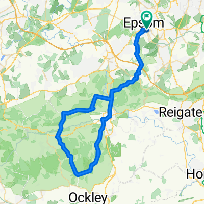
Unusable bikemap!
A cycling route starting in Epsom, England, United Kingdom.
Overview
About this route
Unable to control bikemap. So counter intuitive. So unhelpful.
- -:--
- Duration
- 104.9 km
- Distance
- 392 m
- Ascent
- 331 m
- Descent
- ---
- Avg. speed
- ---
- Avg. speed
Route quality
Waytypes & surfaces along the route
Waytypes
Road
44.4 km
(42 %)
Quiet road
24.4 km
(23 %)
Surfaces
Paved
45.9 km
(44 %)
Unpaved
0.7 km
(<1 %)
Asphalt
42.6 km
(41 %)
Paving stones
2 km
(2 %)
Continue with Bikemap
Use, edit, or download this cycling route
You would like to ride Unusable bikemap! or customize it for your own trip? Here is what you can do with this Bikemap route:
Free features
- Save this route as favorite or in collections
- Copy & plan your own version of this route
- Split it into stages to create a multi-day tour
- Sync your route with Garmin or Wahoo
Premium features
Free trial for 3 days, or one-time payment. More about Bikemap Premium.
- Navigate this route on iOS & Android
- Export a GPX / KML file of this route
- Create your custom printout (try it for free)
- Download this route for offline navigation
Discover more Premium features.
Get Bikemap PremiumFrom our community
Other popular routes starting in Epsom
- 30km Reigate
- Distance
- 30.6 km
- Ascent
- 350 m
- Descent
- 348 m
- Location
- Epsom, England, United Kingdom
- epsom plan
- Distance
- 32.3 km
- Ascent
- 522 m
- Descent
- 519 m
- Location
- Epsom, England, United Kingdom
- 30 miler through cobham
- Distance
- 49.2 km
- Ascent
- 405 m
- Descent
- 404 m
- Location
- Epsom, England, United Kingdom
- Around LH clockwise
- Distance
- 47.5 km
- Ascent
- 305 m
- Descent
- 316 m
- Location
- Epsom, England, United Kingdom
- 40km Box Hill-Reigate
- Distance
- 40.1 km
- Ascent
- 507 m
- Descent
- 508 m
- Location
- Epsom, England, United Kingdom
- Unusable bikemap!
- Distance
- 104.9 km
- Ascent
- 392 m
- Descent
- 331 m
- Location
- Epsom, England, United Kingdom
- Box Hill Loop
- Distance
- 33.8 km
- Ascent
- 263 m
- Descent
- 265 m
- Location
- Epsom, England, United Kingdom
- MJA to Portsmouth Naval Memorial
- Distance
- 131.2 km
- Ascent
- 1,005 m
- Descent
- 1,023 m
- Location
- Epsom, England, United Kingdom
Open it in the app