- 17 km
- 279 m
- 142 m
- Staré Město, Moravskoslezský kraj, Czechia
Časovka Hyundai - Vyšní Lhoty/Kamenité.
A cycling route starting in Staré Město, Moravskoslezský kraj, Czechia.
Overview
About this route
Time trial in the SPAC race series 2011.
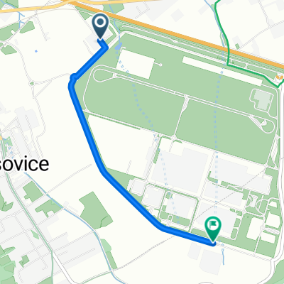
Start from the Integrated Rescue System building on the ring road around the Hyundai factory about 1 km east of the village of Dobrá. The route is guided as a partial loop around the car factory. From this loop, the route leads over an overpass above the highway and railway onto the road between Dobrá and Vojkovice. In Vojkovice, after descending into the village, there is a sharp right turn (exit from the main road to a side road) towards Dobratice. On a long flat stretch under the highway overpass, a climb of about 3 km begins towards the Harenda restaurant, already in Vyšní Lhoty. Here the route turns right and after a short flat section turns left and after a steep climb the finish will be at the Na Kamenitém recreational area in Vyšní Lhoty.
There will be parking and facilities here.
- -:--
- Duration
- 12.2 km
- Distance
- 192 m
- Ascent
- 67 m
- Descent
- ---
- Avg. speed
- ---
- Max. altitude
Route quality
Waytypes & surfaces along the route
Waytypes
Road
6.6 km
(54 %)
Quiet road
3.2 km
(26 %)
Surfaces
Paved
1.7 km
(14 %)
Asphalt
1.7 km
(14 %)
Undefined
10.5 km
(86 %)
Route highlights
Points of interest along the route
Photo after 0 km
Budova IZS.
Point of interest after 0.4 km
Pořadatel. Kruhový objezd.
Photo after 0.4 km
Areál ČEZ.
Photo after 1.5 km
Areál Hyundai.
Point of interest after 2.9 km
Pořadatel. Výjezd od Nošovic.
Point of interest after 3.1 km
Pořadatel. Výjezd od Dobratic-Bukovic.
Point of interest after 4.1 km
Pořadatel. Kruhový objezd.
Point of interest after 4.7 km
Pořadatel. Nadjezd nad dálnicí.
Accommodation after 5.1 km
Restaurace Hotel Nošovice.
Point of interest after 5.2 km
Auto s majákem. Výjezd na hlavní cestu.
Point of interest after 6.9 km
Pořadatel. Odbočka na Dobratice.
Accommodation after 8.1 km
Restaurace U koníčka.
Photo after 8.4 km
Dálniční nadjezd.
Point of interest after 9.1 km
Pořadatel. Výjezd od Bukovic.
Accommodation after 9.4 km
Restaurace Obecník.
Point of interest after 9.5 km
Pořadatel. Výjezd od Hranic.
Point of interest after 10.4 km
Pořadatel. Výjezd od Komorní Lhotky.
Accommodation after 11.7 km
Restaurace Harenda.
Point of interest after 11.8 km
Pořadatel. Výjezd od Komorní Lhotky.
Point of interest after 12 km
Pořadatel. Odbočka na Kamenité.
Drinking water after 12.2 km
C Í L. Parkoviště,zázemí.
Accommodation after 12.2 km
Reastaurace Kohutka.
Continue with Bikemap
Use, edit, or download this cycling route
You would like to ride Časovka Hyundai - Vyšní Lhoty/Kamenité. or customize it for your own trip? Here is what you can do with this Bikemap route:
Free features
- Save this route as favorite or in collections
- Copy & plan your own version of this route
- Sync your route with Garmin or Wahoo
Premium features
Free trial for 3 days, or one-time payment. More about Bikemap Premium.
- Navigate this route on iOS & Android
- Export a GPX / KML file of this route
- Create your custom printout (try it for free)
- Download this route for offline navigation
Discover more Premium features.
Get Bikemap PremiumFrom our community
Other popular routes starting in Staré Město
- Časovka-ArcelorMittal.
- Časovka ArcelorMittal 2012
- 19 km
- 280 m
- 162 m
- Staré Město, Moravskoslezský kraj, Czechia
- Tour de Čupek 2010
- 18 km
- 344 m
- 214 m
- Staré Město, Moravskoslezský kraj, Czechia
- Okolo Lysé cestička
- 51.3 km
- 1,292 m
- 1,293 m
- Staré Město, Moravskoslezský kraj, Czechia
- Časovka Hyundai - Vyšní Lhoty/Kamenité.
- 12.2 km
- 192 m
- 67 m
- Staré Město, Moravskoslezský kraj, Czechia
- Časovka ArcelorMittal 2013
- 19 km
- 281 m
- 165 m
- Staré Město, Moravskoslezský kraj, Czechia
- xxx
- 2.3 km
- 17 m
- 0 m
- Staré Město, Moravskoslezský kraj, Czechia
- Palkovice do Palkovice
- 42.2 km
- 392 m
- 441 m
- Staré Město, Moravskoslezský kraj, Czechia
Open it in the app


