
Časovka Hyundai - Vyšní Lhoty/Kamenité.
A cycling route starting in Staré Město, Moravskoslezský kraj, Czechia.
Overview
About this route
Time trial in the SPAC 2011 racing series.
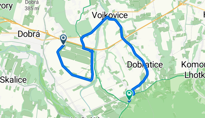
The time trial starts at the Integrated Rescue System building on the ring road around the Hyundai car factory in Nošovice (approximately 2 km east of the village of Dobrá). The route goes in a circle around the car factory up to the overpass over the highway. Here it turns right at the overpass. After a short section, it connects to the main road Dobrá-Vojkovice. Next is the descent into Vojkovice. In the village, there is a sharp turn to the right towards Dobratice. After a long straight section, the course begins to climb under the highway bridge in the village of Dobratice. After about 3 km of climbing to the Harenda restaurant, the course turns right and then left on a short straight. Following is a steep climb of about 500 m to the finish at the viewpoint at Kamenitém in Vyšních Lhotách.
There will also be parking and facilities for competitors here.
- -:--
- Duration
- 12.3 km
- Distance
- 193 m
- Ascent
- 68 m
- Descent
- ---
- Avg. speed
- ---
- Max. altitude
Route quality
Waytypes & surfaces along the route
Waytypes
Road
6.6 km
(54 %)
Quiet road
3.3 km
(27 %)
Surfaces
Paved
1.7 km
(14 %)
Asphalt
1.7 km
(14 %)
Undefined
10.5 km
(86 %)
Route highlights
Points of interest along the route
Photo after 0 km
Budova IZS.
Point of interest after 0 km
START.
Point of interest after 0.4 km
Pořadatel. Kruhový objezd.
Photo after 0.4 km
Areál ČEZ.
Photo after 1.5 km
Areál Hyundai.
Point of interest after 2.9 km
Pořadatel. Výjezd od Nošovic.
Point of interest after 3.1 km
Pořadatel. Výjezd od Dobratic.
Point of interest after 3.1 km
Point of interest after 4.1 km
Pořadatel. Kruhový objezd.
Point of interest after 4.7 km
Pořadatel. Nadjezd nad dálnicí.
Accommodation after 5.1 km
Restaurace Hotel Nošovice.
Point of interest after 5.2 km
Auto pořadatelů s majákem.
Point of interest after 6.9 km
Pořadatel. Odbočka na Dobratice.
Accommodation after 8.1 km
Restaurace U koníčka.
Photo after 8.4 km
Dálniční most.
Point of interest after 9.1 km
Pořadatel. Výjezd od Bukovic.
Accommodation after 9.5 km
Restaurace Obecník.
Point of interest after 9.5 km
Pořadatel. Výjezd u Obecního úřadu.
Point of interest after 10.4 km
Pořadatel. Výjezd od Komorní Lhotky.
Accommodation after 11.7 km
Restaurace Harenda.
Point of interest after 11.8 km
Pořadatel. Výjezd od Komorní Lhotky.
Point of interest after 12 km
Pořadatel. Odočka na Kamenité.
Drinking water after 12.2 km
C Í L. Parkoviště a zázemí.
Accommodation after 12.3 km
Restaurace Kohutka.
Continue with Bikemap
Use, edit, or download this cycling route
You would like to ride Časovka Hyundai - Vyšní Lhoty/Kamenité. or customize it for your own trip? Here is what you can do with this Bikemap route:
Free features
- Save this route as favorite or in collections
- Copy & plan your own version of this route
- Sync your route with Garmin or Wahoo
Premium features
Free trial for 3 days, or one-time payment. More about Bikemap Premium.
- Navigate this route on iOS & Android
- Export a GPX / KML file of this route
- Create your custom printout (try it for free)
- Download this route for offline navigation
Discover more Premium features.
Get Bikemap PremiumFrom our community
Other popular routes starting in Staré Město
 Časovka ArcelorMittal 2012
- Distance
- 19 km
- Ascent
- 261 m
- Descent
- 151 m
- Location
- Staré Město, Moravskoslezský kraj, Czechia
 Časovka Arcelor-Mittal Hyundai - Na Kamenitém.
- Distance
- 12.2 km
- Ascent
- 191 m
- Descent
- 66 m
- Location
- Staré Město, Moravskoslezský kraj, Czechia
 Okolo Lysé cestička
- Distance
- 51.3 km
- Ascent
- 1,292 m
- Descent
- 1,293 m
- Location
- Staré Město, Moravskoslezský kraj, Czechia
 Časovka ArcelorMittal
- Distance
- 17 km
- Ascent
- 280 m
- Descent
- 143 m
- Location
- Staré Město, Moravskoslezský kraj, Czechia
 Časovka Hyundai - Vyšní Lhoty/Kamenité.
- Distance
- 12.3 km
- Ascent
- 193 m
- Descent
- 68 m
- Location
- Staré Město, Moravskoslezský kraj, Czechia
 Časovka Hyundai - Kohutka
- Distance
- 16.9 km
- Ascent
- 295 m
- Descent
- 158 m
- Location
- Staré Město, Moravskoslezský kraj, Czechia
 Časovka ArcelorMittal 2012
- Distance
- 17.1 km
- Ascent
- 286 m
- Descent
- 146 m
- Location
- Staré Město, Moravskoslezský kraj, Czechia
 Časovka Hyundai - restaurace Kohutka
- Distance
- 17.4 km
- Ascent
- 294 m
- Descent
- 157 m
- Location
- Staré Město, Moravskoslezský kraj, Czechia
Open it in the app