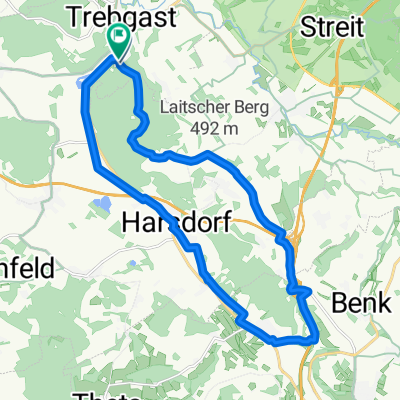
Oberlaitschweg Trebgast - Windrad - Ramsenthal - Harsdorf
A cycling route starting in Trebgast, Bavaria, Germany.
Overview
About this route
Mountain bike trail rather easy to medium. Initially a steep, 3 km climb to Oberlaitsch. On the plateau, it goes over to the wind turbine.
From the wind turbine along the highway (long descent) towards Ramsenthal, returning on the bike path back to Trebgast.
- -:--
- Duration
- 19.4 km
- Distance
- 203 m
- Ascent
- 213 m
- Descent
- ---
- Avg. speed
- ---
- Max. altitude
Route highlights
Points of interest along the route
Point of interest after 7.4 km
Windrad Bindlacher Berg
Continue with Bikemap
Use, edit, or download this cycling route
You would like to ride Oberlaitschweg Trebgast - Windrad - Ramsenthal - Harsdorf or customize it for your own trip? Here is what you can do with this Bikemap route:
Free features
- Save this route as favorite or in collections
- Copy & plan your own version of this route
- Sync your route with Garmin or Wahoo
Premium features
Free trial for 3 days, or one-time payment. More about Bikemap Premium.
- Navigate this route on iOS & Android
- Export a GPX / KML file of this route
- Create your custom printout (try it for free)
- Download this route for offline navigation
Discover more Premium features.
Get Bikemap PremiumFrom our community
Other popular routes starting in Trebgast
Einfach - Trebgast nach Kulmbach- Distance
- 14.8 km
- Ascent
- 158 m
- Descent
- 174 m
- Location
- Trebgast, Bavaria, Germany
2. Tag Trebgast-Bayreuth 04.07.17- Distance
- 49.2 km
- Ascent
- 205 m
- Descent
- 193 m
- Location
- Trebgast, Bavaria, Germany
Runde Ideal- Distance
- 12.4 km
- Ascent
- 157 m
- Descent
- 157 m
- Location
- Trebgast, Bavaria, Germany
Einkehr im Sonnenhof- Distance
- 10.6 km
- Ascent
- 118 m
- Descent
- 38 m
- Location
- Trebgast, Bavaria, Germany
2021 Trebgast Bischofsgrün Warmensteinach- Distance
- 70.1 km
- Ascent
- 507 m
- Descent
- 500 m
- Location
- Trebgast, Bavaria, Germany
Trebgast Theta- Distance
- 31.7 km
- Ascent
- 301 m
- Descent
- 298 m
- Location
- Trebgast, Bavaria, Germany
Autofreier Sonntag Route 1- Distance
- 20.1 km
- Ascent
- 401 m
- Descent
- 411 m
- Location
- Trebgast, Bavaria, Germany
Oberlaitscher Berg- Distance
- 2.5 km
- Ascent
- 110 m
- Descent
- 0 m
- Location
- Trebgast, Bavaria, Germany
Open it in the app

