

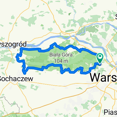
Kampinoski Park Narodowy
A cycling route starting in Izabelin, Masovian Voivodeship, Poland.
Overview
About this route
- -:--
- Duration
- 22.3 km
- Distance
- 64 m
- Ascent
- 65 m
- Descent
- ---
- Avg. speed
- ---
- Max. altitude

Route quality
Waytypes & surfaces along the route
Waytypes
Path
10.4 km
(47 %)
Track
10.2 km
(46 %)
Surfaces
Paved
1.1 km
(5 %)
Unpaved
11.9 km
(53 %)
Ground
5.9 km
(27 %)
Sand
3.9 km
(18 %)
Continue with Bikemap
Use, edit, or download this cycling route
You would like to ride Kampinoski Park Narodowy or customize it for your own trip? Here is what you can do with this Bikemap route:
Free features
- Save this route as favorite or in collections
- Copy & plan your own version of this route
- Sync your route with Garmin or Wahoo
Premium features
Free trial for 3 days, or one-time payment. More about Bikemap Premium.
- Navigate this route on iOS & Android
- Export a GPX / KML file of this route
- Create your custom printout (try it for free)
- Download this route for offline navigation
Discover more Premium features.
Get Bikemap PremiumFrom our community
Other popular routes starting in Izabelin
 kampinos 1
- Distance
- 6.5 km
- Ascent
- 18 m
- Descent
- 17 m
- Location
- Izabelin, Masovian Voivodeship, Poland
![[run] 7,8 km przez Górę Ojca](https://media.bikemap.net/routes/2880758/staticmaps/in_a01546f4-1a9f-44bf-a089-d0e1ac6acee6_400x400_bikemap-2021-3D-static.png) [run] 7,8 km przez Górę Ojca
[run] 7,8 km przez Górę Ojca- Distance
- 7.9 km
- Ascent
- 28 m
- Descent
- 43 m
- Location
- Izabelin, Masovian Voivodeship, Poland
 Kampinowski Szlak Rowerowy
- Distance
- 137.6 km
- Ascent
- 153 m
- Descent
- 158 m
- Location
- Izabelin, Masovian Voivodeship, Poland
 Kampinoski Park Narodowy
- Distance
- 22.3 km
- Ascent
- 64 m
- Descent
- 65 m
- Location
- Izabelin, Masovian Voivodeship, Poland
 KAMPINOSKI SZLAK ROWEROWY
- Distance
- 133.6 km
- Ascent
- 459 m
- Descent
- 462 m
- Location
- Izabelin, Masovian Voivodeship, Poland
 kampinos1
- Distance
- 35.9 km
- Ascent
- 80 m
- Descent
- 79 m
- Location
- Izabelin, Masovian Voivodeship, Poland
 Friedensradfahrt 2009 Paris - Moskau 26. Etappe Izabelin - Warszawa am 2. August 2009
- Distance
- 29.9 km
- Ascent
- 65 m
- Descent
- 58 m
- Location
- Izabelin, Masovian Voivodeship, Poland
 Rękopis 43a, Warszawa do Rękopis 43a, Warszawa
- Distance
- 134.5 km
- Ascent
- 149 m
- Descent
- 149 m
- Location
- Izabelin, Masovian Voivodeship, Poland
Open it in the app