Lubie艅 - Tokarnia - Wieprzec - Osielec - 艁臋townia - Tokarnia - Lubie艅
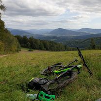
A cycling route starting in Pcim, Lesser Poland Voivodeship, Poland.
Overview
About this route
Do Osielca trasa prawie ca艂y czas idzie pod g贸re. W du偶ej cz臋sci nowym asfaltem ale cz臋sciowo niestety te偶 starym. 4 konkretne podjazdy. Dwa z nich ko艅cz膮 si臋 bardzo sztywno. Wg licznika 54 km
- -:--
- Duration
- 46.4 km
- Distance
- 768 m
- Ascent
- 674 m
- Descent
- ---
- Avg. speed
- ---
- Avg. speed
Route quality
Waytypes & surfaces along the route
Waytypes
Road
39.1 km
(84 %)
Quiet road
2.8 km
(6 %)
Surfaces
Paved
36.5 km
(79 %)
Unpaved
0.1 km
(<1 %)
Asphalt
34.9 km
(75 %)
Paving stones
1 km
(2 %)
Continue with Bikemap
Use, edit, or download this cycling route
You would like to ride Lubie艅 - Tokarnia - Wieprzec - Osielec - 艁臋townia - Tokarnia - Lubie艅 or customize it for your own trip? Here is what you can do with this Bikemap route:
Free features
- Save this route as favorite or in collections
- Copy & plan your own version of this route
- Sync your route with Garmin or Wahoo
Premium features
Free trial for 3 days, or one-time payment. More about Bikemap Premium.
- Navigate this route on iOS & Android
- Export a GPX / KML file of this route
- Create your custom printout (try it for free)
- Download this route for offline navigation
Discover more Premium features.
Get Bikemap PremiumFrom our community
Other popular routes starting in Pcim
- Lubie艅 - Tokarnia - Wieprzec - Osielec - 艁臋townia - Tokarnia - Lubie艅
- Distance
- 46.4 km
- Ascent
- 768 m
- Descent
- 674 m
- Location
- Pcim, Lesser Poland Voivodeship, Poland
- pcim - kudlacze - golec - pcim
- Distance
- 40 km
- Ascent
- 1,170 m
- Descent
- 1,170 m
- Location
- Pcim, Lesser Poland Voivodeship, Poland
- Parszywka i Koto艅 z Pcimia
- Distance
- 38.1 km
- Ascent
- 1,039 m
- Descent
- 1,039 m
- Location
- Pcim, Lesser Poland Voivodeship, Poland
- Pcim "v3.2" (Koto艅)
- Distance
- 39.2 km
- Ascent
- 907 m
- Descent
- 907 m
- Location
- Pcim, Lesser Poland Voivodeship, Poland
- myslenice-str贸偶a-pcim
- Distance
- 40.3 km
- Ascent
- 815 m
- Descent
- 823 m
- Location
- Pcim, Lesser Poland Voivodeship, Poland
- Pasmo Koskowej G贸ry
- Distance
- 55.1 km
- Ascent
- 1,214 m
- Descent
- 1,217 m
- Location
- Pcim, Lesser Poland Voivodeship, Poland
- Pcim - Mak贸w - Pcim
- Distance
- 60.2 km
- Ascent
- 776 m
- Descent
- 774 m
- Location
- Pcim, Lesser Poland Voivodeship, Poland
- Mszana Dolna 95km
- Distance
- 92.8 km
- Ascent
- 898 m
- Descent
- 898 m
- Location
- Pcim, Lesser Poland Voivodeship, Poland
Open it in the app