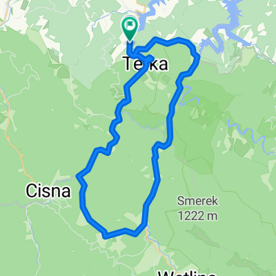
- 58.3 km
- 726 m
- 726 m
- Pola艅czyk, Subcarpathian Voivodeship, Poland
G贸rskie Kolarstwo
A cycling route starting in Pola艅czyk, Subcarpathian Voivodeship, Poland.
Overview
About this route
We start in Wo艂kowyi(near the ranch center)As we approach Pola艅czyk(on the left side, we will see the church)In Myczk贸w, we turn towards Solina... and reach the dam... we can go inside and take a look :)Next, we will ride towards Lesko....(on the left side in Glinny we will see the Leski stone)Then we will ride on roads...the surface is a bit rough... towards G贸rzanka
- -:--
- Duration
- 58.3 km
- Distance
- 726 m
- Ascent
- 726 m
- Descent
- ---
- Avg. speed
- ---
- Max. altitude
created this 14 years ago
Route quality
Waytypes & surfaces along the route
Waytypes
Road
11.1 km
(19 %)
Access road
2.3 km
(4 %)
Surfaces
Paved
52.5 km
(90 %)
Unpaved
3.5 km
(6 %)
Asphalt
52.5 km
(90 %)
Ground
2.3 km
(4 %)
Route highlights
Points of interest along the route
Point of interest after 4.3 km
Ko艣ci贸艂 Pola艅czyk
Point of interest after 52.9 km
Dom patryka
Continue with Bikemap
Use, edit, or download this cycling route
You would like to ride G贸rskie Kolarstwo or customize it for your own trip? Here is what you can do with this Bikemap route:
Free features
- Save this route as favorite or in collections
- Copy & plan your own version of this route
- Sync your route with Garmin or Wahoo
Premium features
Free trial for 3 days, or one-time payment. More about Bikemap Premium.
- Navigate this route on iOS & Android
- Export a GPX / KML file of this route
- Create your custom printout (try it for free)
- Download this route for offline navigation
Discover more Premium features.
Get Bikemap PremiumFrom our community
Other popular routes starting in Pola艅czyk
- G贸rskie Kolarstwo
- Pola艅czyk-Wo艂kowyja-G贸rzanka-G贸rzanka Stok贸wka Polanki-Sine Wiry-Zatwarnica-S臋kowiec-Stok贸wka Studenne Bukowiec-Wo艂kowyja-Pola艅czyk.
- 80.8 km
- 1,412 m
- 1,413 m
- Pola艅czyk, Subcarpathian Voivodeship, Poland
- Rajskie - Zatwarnica - Rajskie
- 31.9 km
- 530 m
- 523 m
- Pola艅czyk, Subcarpathian Voivodeship, Poland
- Bieszczady trip
- 21.8 km
- 643 m
- 651 m
- Pola艅czyk, Subcarpathian Voivodeship, Poland
- wycieczka rekreacyjna
- 46.4 km
- 580 m
- 577 m
- Pola艅czyk, Subcarpathian Voivodeship, Poland
- Dworska 4a, Pola艅czyk do Dworska 4a, Pola艅czyk
- 89.9 km
- 1,153 m
- 1,161 m
- Pola艅czyk, Subcarpathian Voivodeship, Poland
- Bezmiechowa-S艂onne-Ar艂am贸w
- 200.8 km
- 1,664 m
- 1,664 m
- Pola艅czyk, Subcarpathian Voivodeship, Poland
- Do Wodogrzmot贸w
- 37.5 km
- 585 m
- 585 m
- Pola艅czyk, Subcarpathian Voivodeship, Poland
Open it in the app


