

Abendrunde
A cycling route starting in Mönchengladbach, North Rhine-Westphalia, Germany.
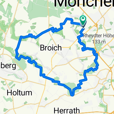
Overview
About this route
MG-Ohler -> Venn -> Lelow -> NATO Headquarters (bring your ID!) -> Rickelrath -> Broich -> Hehn -> Ohler.
- -:--
- Duration
- 30.4 km
- Distance
- 38 m
- Ascent
- 36 m
- Descent
- ---
- Avg. speed
- 81 m
- Max. altitude
Route quality
Waytypes & surfaces along the route
Waytypes
Track
8.8 km
(29 %)
Path
7.9 km
(26 %)
Surfaces
Paved
10.6 km
(35 %)
Unpaved
6.7 km
(22 %)
Asphalt
9.1 km
(30 %)
Unpaved (undefined)
2.7 km
(9 %)
Route highlights
Points of interest along the route
Point of interest after 12 km
Hier fährt man durch einen schmalen Pfad seitlich ins NATO-Hauptquartier ein. (Sicherheitshalber Personalausweis mitnehmen!)
Point of interest after 19.1 km
Modellflughafen: Wenn man Glück hat, kann man hier auch mal nen Hubschauberstart beobachten.
Continue with Bikemap
Use, edit, or download this cycling route
You would like to ride Abendrunde or customize it for your own trip? Here is what you can do with this Bikemap route:
Free features
- Save this route as favorite or in collections
- Copy & plan your own version of this route
- Sync your route with Garmin or Wahoo
Premium features
Free trial for 3 days, or one-time payment. More about Bikemap Premium.
- Navigate this route on iOS & Android
- Export a GPX / KML file of this route
- Create your custom printout (try it for free)
- Download this route for offline navigation
Discover more Premium features.
Get Bikemap PremiumFrom our community
Other popular routes starting in Mönchengladbach
 Schöne Rennradstrecke(de Meinweg)
- Distance
- 74.4 km
- Ascent
- 197 m
- Descent
- 177 m
- Location
- Mönchengladbach, North Rhine-Westphalia, Germany
 Venn-Holtmühle-Tüschenbroich-Venn
- Distance
- 41.5 km
- Ascent
- 85 m
- Descent
- 83 m
- Location
- Mönchengladbach, North Rhine-Westphalia, Germany
 Offroad-Bike-Tour über Stock und Stein (1)
- Distance
- 31.7 km
- Ascent
- 122 m
- Descent
- 121 m
- Location
- Mönchengladbach, North Rhine-Westphalia, Germany
 Wasserturm --> West
- Distance
- 57.6 km
- Ascent
- 82 m
- Descent
- 116 m
- Location
- Mönchengladbach, North Rhine-Westphalia, Germany
 Ruckes40
- Distance
- 41.3 km
- Ascent
- 37 m
- Descent
- 43 m
- Location
- Mönchengladbach, North Rhine-Westphalia, Germany
 Haus Horst - Trietenbroich - Volksgarten
- Distance
- 32 km
- Ascent
- 93 m
- Descent
- 88 m
- Location
- Mönchengladbach, North Rhine-Westphalia, Germany
 Hinsbeckerrunde
- Distance
- 64.3 km
- Ascent
- 262 m
- Descent
- 284 m
- Location
- Mönchengladbach, North Rhine-Westphalia, Germany
 Knopsstraße nach Aachen
- Distance
- 64.3 km
- Ascent
- 293 m
- Descent
- 224 m
- Location
- Mönchengladbach, North Rhine-Westphalia, Germany
Open it in the app