
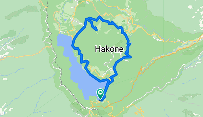
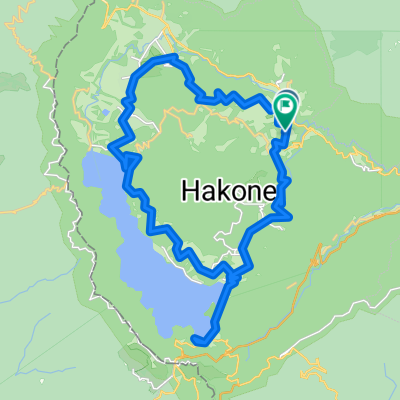
317-1, Hakone, Hakone, Ashigarashimo-Gun to 317-1, Hakone, Hakone, Ashigarashimo-Gun
A cycling route starting in Hakone, Kanagawa, Japan.
Overview
About this route
- 1 h 35 min
- Duration
- 28.8 km
- Distance
- 847 m
- Ascent
- 844 m
- Descent
- 18.1 km/h
- Avg. speed
- ---
- Max. altitude

Continue with Bikemap
Use, edit, or download this cycling route
You would like to ride 317-1, Hakone, Hakone, Ashigarashimo-Gun to 317-1, Hakone, Hakone, Ashigarashimo-Gun or customize it for your own trip? Here is what you can do with this Bikemap route:
Free features
- Save this route as favorite or in collections
- Copy & plan your own version of this route
- Sync your route with Garmin or Wahoo
Premium features
Free trial for 3 days, or one-time payment. More about Bikemap Premium.
- Navigate this route on iOS & Android
- Export a GPX / KML file of this route
- Create your custom printout (try it for free)
- Download this route for offline navigation
Discover more Premium features.
Get Bikemap PremiumFrom our community
Other popular routes starting in Hakone
 箱根到山中湖
- Distance
- 57 km
- Ascent
- 1,157 m
- Descent
- 775 m
- Location
- Hakone, Kanagawa, Japan
 Day 4 - Hakone to Fuji
- Distance
- 54.9 km
- Ascent
- 394 m
- Descent
- 1,201 m
- Location
- Hakone, Kanagawa, Japan
 317-1, Hakone, Hakone, Ashigarashimo-Gun to 317-1, Hakone, Hakone, Ashigarashimo-Gun
- Distance
- 28.8 km
- Ascent
- 847 m
- Descent
- 844 m
- Location
- Hakone, Kanagawa, Japan
 2013/05/03箱根周遊
- Distance
- 36.5 km
- Ascent
- 813 m
- Descent
- 810 m
- Location
- Hakone, Kanagawa, Japan
 164-1, Motohakone, Hakone, Ashigarashimo-Gun to 70-3, Yumoto, Hakone, Ashigarashimo-Gun
- Distance
- 19 km
- Ascent
- 484 m
- Descent
- 1,154 m
- Location
- Hakone, Kanagawa, Japan
 2017/2/6
- Distance
- 75.9 km
- Ascent
- 103 m
- Descent
- 895 m
- Location
- Hakone, Kanagawa, Japan
 東海道 to 御成通り
- Distance
- 60.4 km
- Ascent
- 664 m
- Descent
- 1,399 m
- Location
- Hakone, Kanagawa, Japan
 1_8_HAKONE_HIRATSUKA_40km_200m
- Distance
- 40.1 km
- Ascent
- 233 m
- Descent
- 914 m
- Location
- Hakone, Kanagawa, Japan
Open it in the app