
Incheon to Busan Day 3
A cycling route starting in Mungyeong, Gyeongsangbuk-do, South Korea.
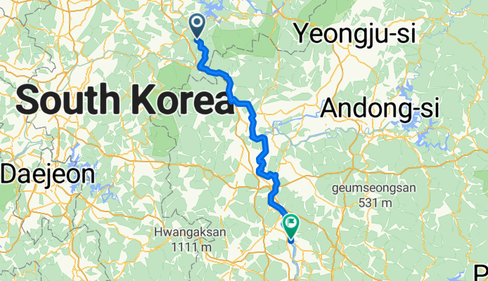
Overview
About this route
- -:--
- Duration
- 121.6 km
- Distance
- 510 m
- Ascent
- 669 m
- Descent
- ---
- Avg. speed
- ---
- Max. altitude

Route quality
Waytypes & surfaces along the route
Waytypes
Cycleway
59.7 km
(49 %)
Road
28.7 km
(24 %)
Surfaces
Paved
112.4 km
(92 %)
Unpaved
0.4 km
(<1 %)
Asphalt
96.1 km
(79 %)
Concrete
16.2 km
(13 %)
Continue with Bikemap
Use, edit, or download this cycling route
You would like to ride Incheon to Busan Day 3 or customize it for your own trip? Here is what you can do with this Bikemap route:
Free features
- Save this route as favorite or in collections
- Copy & plan your own version of this route
- Split it into stages to create a multi-day tour
- Sync your route with Garmin or Wahoo
Premium features
Free trial for 3 days, or one-time payment. More about Bikemap Premium.
- Navigate this route on iOS & Android
- Export a GPX / KML file of this route
- Create your custom printout (try it for free)
- Download this route for offline navigation
Discover more Premium features.
Get Bikemap PremiumFrom our community
Other popular routes starting in Mungyeong
 200-9, Oncheon-ri, Chungju-si naar 303, Hwacheon-ri, Chungju-si
- Distance
- 3.3 km
- Ascent
- 72 m
- Descent
- 33 m
- Location
- Mungyeong, Gyeongsangbuk-do, South Korea
 괴산메디오폰도
- Distance
- 106.6 km
- Ascent
- 2,326 m
- Descent
- 2,035 m
- Location
- Mungyeong, Gyeongsangbuk-do, South Korea
 hotel
hotel- Distance
- 26.3 km
- Ascent
- 227 m
- Descent
- 307 m
- Location
- Mungyeong, Gyeongsangbuk-do, South Korea
 Ewha Pass uphill course_New updated
- Distance
- 4.9 km
- Ascent
- 315 m
- Descent
- 35 m
- Location
- Mungyeong, Gyeongsangbuk-do, South Korea
 Suanbo - Nakdong-Ri Gumi-Si (D3)
- Distance
- 106.4 km
- Ascent
- 1,175 m
- Descent
- 1,330 m
- Location
- Mungyeong, Gyeongsangbuk-do, South Korea
 3rd day Suanbo - Sangju City
- Distance
- 94.8 km
- Ascent
- 992 m
- Descent
- 1,200 m
- Location
- Mungyeong, Gyeongsangbuk-do, South Korea
 수안보면 446−7, 충주시 to 수안보면 279−9, 충주시
- Distance
- 98.4 km
- Ascent
- 1,164 m
- Descent
- 1,174 m
- Location
- Mungyeong, Gyeongsangbuk-do, South Korea
 韓国縦走サイクリング5日目(水安堡→楊平)
- Distance
- 148.9 km
- Ascent
- 300 m
- Descent
- 459 m
- Location
- Mungyeong, Gyeongsangbuk-do, South Korea
Open it in the app