

Große Rüdersdorfer Runde
A cycling route starting in Karlshorst, State of Berlin, Germany.
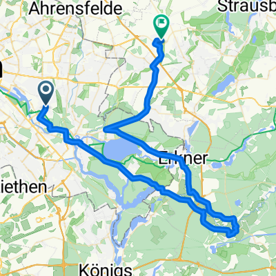
Overview
About this route
Route with 3 small climbs in Rüdersdorf (1x cobblestone), expandable by loops/detours in Grünheide or via Erkner/Gosen/Müggelheim or Erkner/Wernsdorf/Schmöckwitz/Grünau, shortenable via Woltersdorf/Erkner
- -:--
- Duration
- 59.9 km
- Distance
- 163 m
- Ascent
- 163 m
- Descent
- ---
- Avg. speed
- 78 m
- Max. altitude
Route quality
Waytypes & surfaces along the route
Waytypes
Path
12 km
(20 %)
Road
10.2 km
(17 %)
Surfaces
Paved
45.5 km
(76 %)
Unpaved
0.6 km
(1 %)
Asphalt
43.7 km
(73 %)
Concrete
1.8 km
(3 %)
Continue with Bikemap
Use, edit, or download this cycling route
You would like to ride Große Rüdersdorfer Runde or customize it for your own trip? Here is what you can do with this Bikemap route:
Free features
- Save this route as favorite or in collections
- Copy & plan your own version of this route
- Sync your route with Garmin or Wahoo
Premium features
Free trial for 3 days, or one-time payment. More about Bikemap Premium.
- Navigate this route on iOS & Android
- Export a GPX / KML file of this route
- Create your custom printout (try it for free)
- Download this route for offline navigation
Discover more Premium features.
Get Bikemap PremiumFrom our community
Other popular routes starting in Karlshorst
 Über Bernau
- Distance
- 75.7 km
- Ascent
- 184 m
- Descent
- 185 m
- Location
- Karlshorst, State of Berlin, Germany
 RR Müggelsee Erkner Altlandsberg Hönow
- Distance
- 72.1 km
- Ascent
- 61 m
- Descent
- 62 m
- Location
- Karlshorst, State of Berlin, Germany
 Rund um den Müggelsee
- Distance
- 44.8 km
- Ascent
- 142 m
- Descent
- 140 m
- Location
- Karlshorst, State of Berlin, Germany
 Rund um den Müggelsee
- Distance
- 41 km
- Ascent
- 76 m
- Descent
- 76 m
- Location
- Karlshorst, State of Berlin, Germany
 Garten - Holly - Karlshorst
- Distance
- 68.9 km
- Ascent
- 247 m
- Descent
- 228 m
- Location
- Karlshorst, State of Berlin, Germany
 Große Rüdersdorfer Runde
- Distance
- 59.9 km
- Ascent
- 163 m
- Descent
- 163 m
- Location
- Karlshorst, State of Berlin, Germany
 Karlshorst - Bad Freienwalde - Strausberg Runde
- Distance
- 125.3 km
- Ascent
- 249 m
- Descent
- 249 m
- Location
- Karlshorst, State of Berlin, Germany
 Odertour Idee
- Distance
- 340.6 km
- Ascent
- 1,240 m
- Descent
- 1,240 m
- Location
- Karlshorst, State of Berlin, Germany
Open it in the app