

Giro del Monte Campo dei Fiori
A cycling route starting in Cadrezzate, Lombardy, Italy.
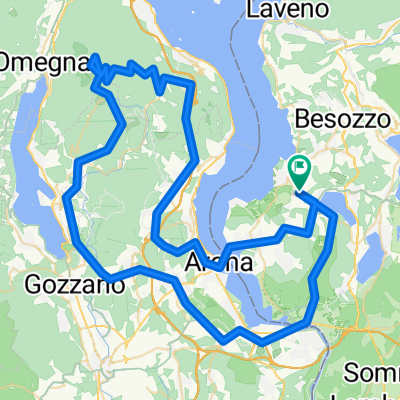
Overview
About this route
Probably the most beautiful track starting from the JRC, most time with little traffic, some nice views. The Campo dei Fiori peak can be skipted. Distance: 66.5 km time 4:11 h climb 1317 meters Max elevation 1179 meters (excluding the peak) Distance 49.05 km time 2:45 h climb 653 meters Max elevation 580 meters.
- -:--
- Duration
- 67.1 km
- Distance
- 1,166 m
- Ascent
- 1,166 m
- Descent
- ---
- Avg. speed
- ---
- Max. altitude

Continue with Bikemap
Use, edit, or download this cycling route
You would like to ride Giro del Monte Campo dei Fiori or customize it for your own trip? Here is what you can do with this Bikemap route:
Free features
- Save this route as favorite or in collections
- Copy & plan your own version of this route
- Sync your route with Garmin or Wahoo
Premium features
Free trial for 3 days, or one-time payment. More about Bikemap Premium.
- Navigate this route on iOS & Android
- Export a GPX / KML file of this route
- Create your custom printout (try it for free)
- Download this route for offline navigation
Discover more Premium features.
Get Bikemap PremiumFrom our community
Other popular routes starting in Cadrezzate
 Lunch break 1 Largo di Conabio
- Distance
- 27.9 km
- Ascent
- 255 m
- Descent
- 255 m
- Location
- Cadrezzate, Lombardy, Italy
 Giro del Monte Campo dei Fiori
- Distance
- 67.1 km
- Ascent
- 1,166 m
- Descent
- 1,166 m
- Location
- Cadrezzate, Lombardy, Italy
 Bike to Malpensa (T1)!!!
- Distance
- 31.3 km
- Ascent
- 214 m
- Descent
- 225 m
- Location
- Cadrezzate, Lombardy, Italy
 Bike to Malpensa (T2)!!!
- Distance
- 24.5 km
- Ascent
- 177 m
- Descent
- 178 m
- Location
- Cadrezzate, Lombardy, Italy
 Mottarone
- Distance
- 101.6 km
- Ascent
- 1,532 m
- Descent
- 1,532 m
- Location
- Cadrezzate, Lombardy, Italy
 lunch break 2 Santuario di S. Clemente
- Distance
- 25.4 km
- Ascent
- 357 m
- Descent
- 360 m
- Location
- Cadrezzate, Lombardy, Italy
 Ispra Lugano e ritorno
- Distance
- 88 km
- Ascent
- 726 m
- Descent
- 753 m
- Location
- Cadrezzate, Lombardy, Italy
 Giro Lago Maggiore
- Distance
- 166.8 km
- Ascent
- 2,252 m
- Descent
- 2,292 m
- Location
- Cadrezzate, Lombardy, Italy
Open it in the app