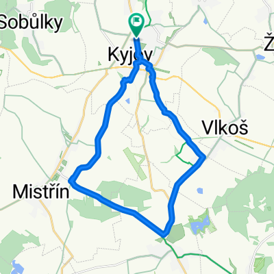
CP_CASOVKA_KYJOV_2021
A cycling route starting in Kyjov, South Moravian, Czechia.
Overview
About this route
- -:--
- Duration
- 6.5 km
- Distance
- 149 m
- Ascent
- 35 m
- Descent
- ---
- Avg. speed
- ---
- Avg. speed
Route quality
Waytypes & surfaces along the route
Waytypes
Road
6 km
(92 %)
Busy road
0.5 km
(8 %)
Undefined
0 km
(<1 %)
Surfaces
Paved
0.5 km
(8 %)
Asphalt
0.5 km
(8 %)
Undefined
6 km
(92 %)
Route highlights
Points of interest along the route
Point of interest after 4.1 km
Otočka 1
Continue with Bikemap
Use, edit, or download this cycling route
You would like to ride CP_CASOVKA_KYJOV_2021 or customize it for your own trip? Here is what you can do with this Bikemap route:
Free features
- Save this route as favorite or in collections
- Copy & plan your own version of this route
- Sync your route with Garmin or Wahoo
Premium features
Free trial for 3 days, or one-time payment. More about Bikemap Premium.
- Navigate this route on iOS & Android
- Export a GPX / KML file of this route
- Create your custom printout (try it for free)
- Download this route for offline navigation
Discover more Premium features.
Get Bikemap PremiumFrom our community
Other popular routes starting in Kyjov
- Kyjov - Buchlovice - Koryčany - Opatovice
- Distance
- 106.8 km
- Ascent
- 800 m
- Descent
- 806 m
- Location
- Kyjov, South Moravian, Czechia
- Nájez na okruh - Muži
- Distance
- 5.9 km
- Ascent
- 182 m
- Descent
- 33 m
- Location
- Kyjov, South Moravian, Czechia
- 1 Penny ZAF (Celoznice - Valtice)
- Distance
- 62 km
- Ascent
- 257 m
- Descent
- 280 m
- Location
- Kyjov, South Moravian, Czechia
- PNNY FARTHING BRNO-INNSBRUCK-VENEZIA-BZ in 17 tappe (via più breve)
- Distance
- 1,401.9 km
- Ascent
- 1,682 m
- Descent
- 1,705 m
- Location
- Kyjov, South Moravian, Czechia
- Trať závodu
- Distance
- 20.7 km
- Ascent
- 327 m
- Descent
- 329 m
- Location
- Kyjov, South Moravian, Czechia
- Kalas Cup 2018
- Distance
- 14.9 km
- Ascent
- 304 m
- Descent
- 301 m
- Location
- Kyjov, South Moravian, Czechia
- kyjov-kyjov
- Distance
- 38.1 km
- Ascent
- 404 m
- Descent
- 398 m
- Location
- Kyjov, South Moravian, Czechia
- Kyjov - Skorotice - Milotice - Ratíškovice - Dubňany - Mutěnice - Svatobořice - Kyjov
- Distance
- 46.8 km
- Ascent
- 204 m
- Descent
- 203 m
- Location
- Kyjov, South Moravian, Czechia
Open it in the app