
DÍA 5
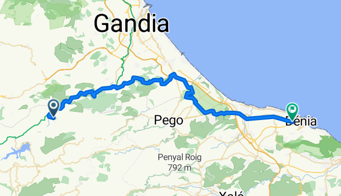
A cycling route starting in Terrateig, Valencia, Spain.
Overview
About this route
- -:--
- Duration
- 52.7 km
- Distance
- 325 m
- Ascent
- 584 m
- Descent
- ---
- Avg. speed
- ---
- Max. altitude

Route quality
Waytypes & surfaces along the route
Waytypes
Track
15.8 km
(30 %)
Quiet road
14.2 km
(27 %)
Surfaces
Paved
5.8 km
(11 %)
Unpaved
14.8 km
(28 %)
Gravel
12.6 km
(24 %)
Asphalt
5.3 km
(10 %)
Route highlights
Points of interest along the route
Accommodation after 0 km
Continue with Bikemap
Use, edit, or download this cycling route
You would like to ride DÍA 5 or customize it for your own trip? Here is what you can do with this Bikemap route:
Free features
- Save this route as favorite or in collections
- Copy & plan your own version of this route
- Sync your route with Garmin or Wahoo
Premium features
Free trial for 3 days, or one-time payment. More about Bikemap Premium.
- Navigate this route on iOS & Android
- Export a GPX / KML file of this route
- Create your custom printout (try it for free)
- Download this route for offline navigation
Discover more Premium features.
Get Bikemap PremiumFrom our community
Other popular routes starting in Terrateig
 DÍA 1
DÍA 1- Distance
- 50 km
- Ascent
- 262 m
- Descent
- 525 m
- Location
- Terrateig, Valencia, Spain
 lorcha
- Distance
- 5.1 km
- Ascent
- 402 m
- Descent
- 81 m
- Location
- Terrateig, Valencia, Spain
 DÍA 2
DÍA 2- Distance
- 59.8 km
- Ascent
- 669 m
- Descent
- 256 m
- Location
- Terrateig, Valencia, Spain
 Lorxa-Castell Carricola-lorxa
- Distance
- 225.8 km
- Ascent
- 2,847 m
- Descent
- 2,847 m
- Location
- Terrateig, Valencia, Spain
 L´ORCHA - BIAR
- Distance
- 60.1 km
- Ascent
- 719 m
- Descent
- 225 m
- Location
- Terrateig, Valencia, Spain
 Vía Verde del Serpis-Circular
- Distance
- 29.3 km
- Ascent
- 908 m
- Descent
- 915 m
- Location
- Terrateig, Valencia, Spain
 Lorxa-Beniarrés-II Marxa Btt Serpis
- Distance
- 35.2 km
- Ascent
- 752 m
- Descent
- 753 m
- Location
- Terrateig, Valencia, Spain
 Lorcha Villalonga
- Distance
- 13.9 km
- Ascent
- 393 m
- Descent
- 566 m
- Location
- Terrateig, Valencia, Spain
Open it in the app