

Su e giù per le colline del Medio Friuli
A cycling route starting in Maniago, Friuli Venezia Giulia, Italy.
Overview
About this route
16 May 2021 Up and down the hills of Middle Friuli
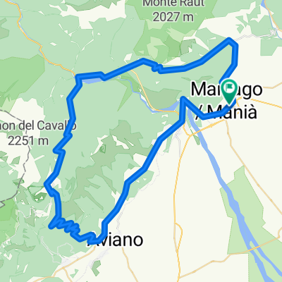
We propose a loop ride starting and ending in Maniago. We will depart from the Ospedale parking lot on Via Unità d'Italia, making our way through the Val Colvera until we reach the village of Poffabro, then we will descend to reach the village of Navarons and then Lake Redona where we will take a small coffee break. We will resume the route which will gradually become harder, passing through Campone and with a nice climb we will arrive at the caves of Pradis. Towards Clauzetto we will follow a gentle descent, upon reaching the church we can stop to enjoy the panorama while having our packed lunch. We will continue to climb to reach Vito D'Asio and then descend toward Casiacco, following the Arzino until the bend to take the climb to Manazzons, take the road to the valley of Cosa, pass by Paludea and, skirting the Cosa, arrive in Travesio. After the deserved coffee break, we will return to Maniago reaching the Ospedale parking lot where we started.
- -:--
- Duration
- 67.2 km
- Distance
- 1,202 m
- Ascent
- 1,478 m
- Descent
- ---
- Avg. speed
- 694 m
- Max. altitude

Route quality
Waytypes & surfaces along the route
Waytypes
Quiet road
26.2 km
(39 %)
Road
25.5 km
(38 %)
Surfaces
Paved
36.3 km
(54 %)
Unpaved
0.7 km
(1 %)
Asphalt
36.3 km
(54 %)
Ground
0.7 km
(1 %)
Undefined
30.2 km
(45 %)
Route highlights
Points of interest along the route

Point of interest after 53.9 km
strada per castello di Toppo
Continue with Bikemap
Use, edit, or download this cycling route
You would like to ride Su e giù per le colline del Medio Friuli or customize it for your own trip? Here is what you can do with this Bikemap route:
Free features
- Save this route as favorite or in collections
- Copy & plan your own version of this route
- Sync your route with Garmin or Wahoo
Premium features
Free trial for 3 days, or one-time payment. More about Bikemap Premium.
- Navigate this route on iOS & Android
- Export a GPX / KML file of this route
- Create your custom printout (try it for free)
- Download this route for offline navigation
Discover more Premium features.
Get Bikemap PremiumFrom our community
Other popular routes starting in Maniago
 Maniago - Barcis - Piancavallo - Maniago
- Distance
- 79.6 km
- Ascent
- 1,656 m
- Descent
- 1,656 m
- Location
- Maniago, Friuli Venezia Giulia, Italy
 2015.3 Maniago - Follina
- Distance
- 77.5 km
- Ascent
- 277 m
- Descent
- 392 m
- Location
- Maniago, Friuli Venezia Giulia, Italy
 Tra verdi acque e montagne
- Distance
- 61.5 km
- Ascent
- 795 m
- Descent
- 797 m
- Location
- Maniago, Friuli Venezia Giulia, Italy
 Forcella palabarzana
- Distance
- 26.1 km
- Ascent
- 1,137 m
- Descent
- 1,134 m
- Location
- Maniago, Friuli Venezia Giulia, Italy
 Su e giù per le colline del Medio Friuli
- Distance
- 67.2 km
- Ascent
- 1,202 m
- Descent
- 1,478 m
- Location
- Maniago, Friuli Venezia Giulia, Italy
 From Maniago to Tramonti di Sopra
- Distance
- 26 km
- Ascent
- 589 m
- Descent
- 450 m
- Location
- Maniago, Friuli Venezia Giulia, Italy
 Maniago-Maniago la 307 anno 1998
- Distance
- 260.2 km
- Ascent
- 4,746 m
- Descent
- 4,737 m
- Location
- Maniago, Friuli Venezia Giulia, Italy
 Maniago sentieri e forcella clautana
- Distance
- 95.7 km
- Ascent
- 2,552 m
- Descent
- 2,553 m
- Location
- Maniago, Friuli Venezia Giulia, Italy
Open it in the app