

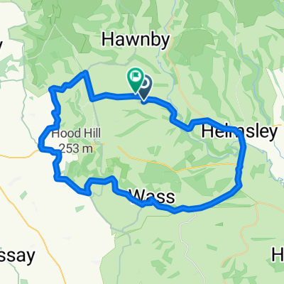
28 miles anti-clockwise
A cycling route starting in Helmsley, England, United Kingdom.
Overview
About this route
Harome Helmsley Sproxton Oswaldkirk Cawton Stonegrave Hovingham Slingsby South Holme Ness Welburn Wombleton
- -:--
- Duration
- 44.1 km
- Distance
- 237 m
- Ascent
- 237 m
- Descent
- ---
- Avg. speed
- ---
- Max. altitude
Route quality
Waytypes & surfaces along the route
Waytypes
Road
17.3 km
(39 %)
Busy road
13.2 km
(30 %)
Surfaces
Paved
25.9 km
(59 %)
Unpaved
0.2 km
(<1 %)
Asphalt
25.9 km
(59 %)
Unpaved (undefined)
0.2 km
(<1 %)
Undefined
18 km
(41 %)
Continue with Bikemap
Use, edit, or download this cycling route
You would like to ride 28 miles anti-clockwise or customize it for your own trip? Here is what you can do with this Bikemap route:
Free features
- Save this route as favorite or in collections
- Copy & plan your own version of this route
- Sync your route with Garmin or Wahoo
Premium features
Free trial for 3 days, or one-time payment. More about Bikemap Premium.
- Navigate this route on iOS & Android
- Export a GPX / KML file of this route
- Create your custom printout (try it for free)
- Download this route for offline navigation
Discover more Premium features.
Get Bikemap PremiumFrom our community
Other popular routes starting in Helmsley
 Miskelly Old Byland-Ampleforth - Helmsley Loop
- Distance
- 45 km
- Ascent
- 624 m
- Descent
- 587 m
- Location
- Helmsley, England, United Kingdom
 28 miles anti-clockwise
- Distance
- 44.1 km
- Ascent
- 237 m
- Descent
- 237 m
- Location
- Helmsley, England, United Kingdom
 NYM7 - Goldeneye Cycling Guide
- Distance
- 35.2 km
- Ascent
- 439 m
- Descent
- 440 m
- Location
- Helmsley, England, United Kingdom
 Helmsley 100819 - 60.3m
- Distance
- 99.8 km
- Ascent
- 955 m
- Descent
- 957 m
- Location
- Helmsley, England, United Kingdom
 North Yorkshire loop
- Distance
- 104.6 km
- Ascent
- 950 m
- Descent
- 947 m
- Location
- Helmsley, England, United Kingdom
 Moors Runde mit Rosedale Bank
- Distance
- 62.8 km
- Ascent
- 927 m
- Descent
- 931 m
- Location
- Helmsley, England, United Kingdom
 Helmsley 140620 - 35.2m
- Distance
- 56.8 km
- Ascent
- 642 m
- Descent
- 642 m
- Location
- Helmsley, England, United Kingdom
 Helmsley Old Byland Dalton 240521 - 46.5m
- Distance
- 75.6 km
- Ascent
- 614 m
- Descent
- 614 m
- Location
- Helmsley, England, United Kingdom
Open it in the app