

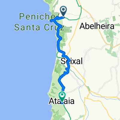
Recovered Route
A cycling route starting in Atouguia da Baleia, Leiria District, Portugal.
Overview
About this route
- 2 h 57 min
- Duration
- 40.9 km
- Distance
- 6 m
- Ascent
- 12 m
- Descent
- 13.9 km/h
- Avg. speed
- ---
- Max. altitude
Continue with Bikemap
Use, edit, or download this cycling route
You would like to ride Recovered Route or customize it for your own trip? Here is what you can do with this Bikemap route:
Free features
- Save this route as favorite or in collections
- Copy & plan your own version of this route
- Sync your route with Garmin or Wahoo
Premium features
Free trial for 3 days, or one-time payment. More about Bikemap Premium.
- Navigate this route on iOS & Android
- Export a GPX / KML file of this route
- Create your custom printout (try it for free)
- Download this route for offline navigation
Discover more Premium features.
Get Bikemap PremiumFrom our community
Other popular routes starting in Atouguia da Baleia
 PJ Baleal
- Distance
- 16.1 km
- Ascent
- 125 m
- Descent
- 128 m
- Location
- Atouguia da Baleia, Leiria District, Portugal
 Passeio_Revisto_20250521_Trilho
- Distance
- 44.2 km
- Ascent
- 400 m
- Descent
- 399 m
- Location
- Atouguia da Baleia, Leiria District, Portugal
 De Rua do Catalo 2520, Ferrel a Avenida Marginal, São Martinho do Porto
- Distance
- 43.9 km
- Ascent
- 1,248 m
- Descent
- 1,342 m
- Location
- Atouguia da Baleia, Leiria District, Portugal
 PJ na Jablka
- Distance
- 31.3 km
- Ascent
- 315 m
- Descent
- 307 m
- Location
- Atouguia da Baleia, Leiria District, Portugal
 Barragem de Sao Domingos
- Distance
- 12.4 km
- Ascent
- 162 m
- Descent
- 159 m
- Location
- Atouguia da Baleia, Leiria District, Portugal
 Recovered Route
- Distance
- 40.9 km
- Ascent
- 6 m
- Descent
- 12 m
- Location
- Atouguia da Baleia, Leiria District, Portugal
 PJ z Ania
- Distance
- 29.4 km
- Ascent
- 316 m
- Descent
- 313 m
- Location
- Atouguia da Baleia, Leiria District, Portugal
 União das freguesias de Lourinhã e Atalaia, Lourinhã to Estrada Nossa Sra da Guia, Atalaia
- Distance
- 9.6 km
- Ascent
- 192 m
- Descent
- 152 m
- Location
- Atouguia da Baleia, Leiria District, Portugal
Open it in the app