

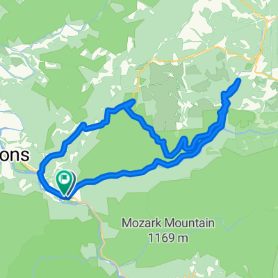
Olson Fire Tower to Parsons
A cycling route starting in Parsons, West Virginia, United States.
Overview
About this route
This is a shuttle ride starting at the Olson Fire Tower and ending at the train station in Parsons. About an eight mile shuttle from the station to the tower.
- -:--
- Duration
- 35.8 km
- Distance
- 96 m
- Ascent
- 710 m
- Descent
- ---
- Avg. speed
- ---
- Max. altitude

Route photos


Route quality
Waytypes & surfaces along the route
Waytypes
Quiet road
15.6 km
(44 %)
Path
14.9 km
(42 %)
Cycleway
5.2 km
(15 %)
Surfaces
Paved
1.7 km
(5 %)
Unpaved
15.7 km
(44 %)
Unpaved (undefined)
14.2 km
(40 %)
Gravel
1.5 km
(4 %)
Route highlights
Points of interest along the route

Point of interest after 5.3 km
Falls of Big Run
Continue with Bikemap
Use, edit, or download this cycling route
You would like to ride Olson Fire Tower to Parsons or customize it for your own trip? Here is what you can do with this Bikemap route:
Free features
- Save this route as favorite or in collections
- Copy & plan your own version of this route
- Sync your route with Garmin or Wahoo
Premium features
Free trial for 3 days, or one-time payment. More about Bikemap Premium.
- Navigate this route on iOS & Android
- Export a GPX / KML file of this route
- Create your custom printout (try it for free)
- Download this route for offline navigation
Discover more Premium features.
Get Bikemap PremiumFrom our community
Other popular routes starting in Parsons
 Olson Fire Tower to Parsons
- Distance
- 35.8 km
- Ascent
- 96 m
- Descent
- 710 m
- Location
- Parsons, West Virginia, United States
 Horseshoe - Limestone Mt. Ride
- Distance
- 55 km
- Ascent
- 677 m
- Descent
- 677 m
- Location
- Parsons, West Virginia, United States
 Second St, Hendricks to Allegheny Highlands Trail of Wv, Hendricks
- Distance
- 39.5 km
- Ascent
- 798 m
- Descent
- 794 m
- Location
- Parsons, West Virginia, United States
 Parsons Radfahren
- Distance
- 35.7 km
- Ascent
- 537 m
- Descent
- 542 m
- Location
- Parsons, West Virginia, United States
 Parsons-Montrose Loop
- Distance
- 61.5 km
- Ascent
- 604 m
- Descent
- 602 m
- Location
- Parsons, West Virginia, United States
 Texas Mountain
- Distance
- 34.7 km
- Ascent
- 502 m
- Descent
- 502 m
- Location
- Parsons, West Virginia, United States
 Bfalls to Moundsville
- Distance
- 201.5 km
- Ascent
- 1,391 m
- Descent
- 2,151 m
- Location
- Parsons, West Virginia, United States
 Limestone Mt. Loop
- Distance
- 33.4 km
- Ascent
- 587 m
- Descent
- 587 m
- Location
- Parsons, West Virginia, United States
Open it in the app