

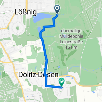
Seenrunde Markkleeberg
A cycling route starting in Markkleeberg, Saxony, Germany.
Overview
About this route
Training route Markkleeberger See (hilly and prone to wind)
Meeting: Seepromenade Parking (extended Bornaische Street)
The loop will be ridden counterclockwise. For all participants who cannot be at the meeting point at the time mentioned in TP, they will ride clockwise towards the others!
- -:--
- Duration
- 31 km
- Distance
- 91 m
- Ascent
- 89 m
- Descent
- ---
- Avg. speed
- ---
- Max. altitude
Route quality
Waytypes & surfaces along the route
Waytypes
Path
11.5 km
(37 %)
Track
7.7 km
(25 %)
Surfaces
Paved
27.9 km
(90 %)
Unpaved
0.3 km
(1 %)
Asphalt
27.9 km
(90 %)
Loose gravel
0.3 km
(1 %)
Undefined
2.8 km
(9 %)
Continue with Bikemap
Use, edit, or download this cycling route
You would like to ride Seenrunde Markkleeberg or customize it for your own trip? Here is what you can do with this Bikemap route:
Free features
- Save this route as favorite or in collections
- Copy & plan your own version of this route
- Sync your route with Garmin or Wahoo
Premium features
Free trial for 3 days, or one-time payment. More about Bikemap Premium.
- Navigate this route on iOS & Android
- Export a GPX / KML file of this route
- Create your custom printout (try it for free)
- Download this route for offline navigation
Discover more Premium features.
Get Bikemap PremiumFrom our community
Other popular routes starting in Markkleeberg
 Durch die Elsteraue
- Distance
- 49.6 km
- Ascent
- 169 m
- Descent
- 166 m
- Location
- Markkleeberg, Saxony, Germany
 Seen-Rundfahrt CLONED FROM ROUTE 324751
- Distance
- 78.3 km
- Ascent
- 145 m
- Descent
- 153 m
- Location
- Markkleeberg, Saxony, Germany
 Quer Feld ein in der Neuen Harth
- Distance
- 6.1 km
- Ascent
- 9 m
- Descent
- 8 m
- Location
- Markkleeberg, Saxony, Germany
 Route in Leipzig
- Distance
- 2.6 km
- Ascent
- 14 m
- Descent
- 7 m
- Location
- Markkleeberg, Saxony, Germany
 Pleißeradweg von Markkleeberg nach Regis-Breitingen
- Distance
- 28.5 km
- Ascent
- 95 m
- Descent
- 50 m
- Location
- Markkleeberg, Saxony, Germany
 Siedlung Goldene Höhe, Markkleeberg nach Am Wolfswinkel, Markkleeberg
- Distance
- 14 km
- Ascent
- 106 m
- Descent
- 112 m
- Location
- Markkleeberg, Saxony, Germany
 Am Wolfswinkel nach Am Wolfswinkel
- Distance
- 21 km
- Ascent
- 107 m
- Descent
- 148 m
- Location
- Markkleeberg, Saxony, Germany
 Route Alt Connewitz
- Distance
- 40.1 km
- Ascent
- 162 m
- Descent
- 162 m
- Location
- Markkleeberg, Saxony, Germany
Open it in the app