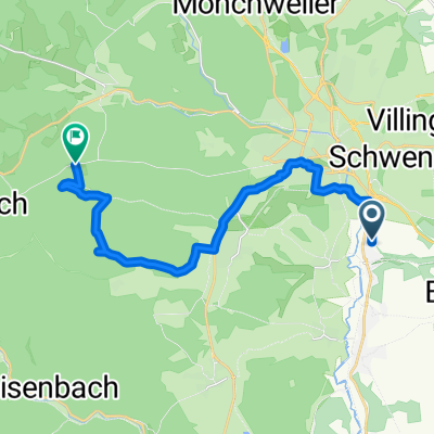
Schöne Runde
A cycling route starting in Villingen-Schwenningen, Baden-Wurttemberg, Germany.
Overview
About this route
- 5 h 31 min
- Duration
- 55.7 km
- Distance
- 993 m
- Ascent
- 992 m
- Descent
- 10.1 km/h
- Avg. speed
- ---
- Max. altitude
Route photos
Route quality
Waytypes & surfaces along the route
Waytypes
Quiet road
16.7 km
(30 %)
Track
15 km
(27 %)
Surfaces
Paved
31.8 km
(57 %)
Unpaved
16.2 km
(29 %)
Asphalt
30.7 km
(55 %)
Loose gravel
8.4 km
(15 %)
Continue with Bikemap
Use, edit, or download this cycling route
You would like to ride Schöne Runde or customize it for your own trip? Here is what you can do with this Bikemap route:
Free features
- Save this route as favorite or in collections
- Copy & plan your own version of this route
- Sync your route with Garmin or Wahoo
Premium features
Free trial for 3 days, or one-time payment. More about Bikemap Premium.
- Navigate this route on iOS & Android
- Export a GPX / KML file of this route
- Create your custom printout (try it for free)
- Download this route for offline navigation
Discover more Premium features.
Get Bikemap PremiumFrom our community
Other popular routes starting in Villingen-Schwenningen
- Ausflug in den Schwarzwald
- Distance
- 63.7 km
- Ascent
- 787 m
- Descent
- 786 m
- Location
- Villingen-Schwenningen, Baden-Wurttemberg, Germany
- Schwenninger-Rundkurs ohne Überland
- Distance
- 35.2 km
- Ascent
- 187 m
- Descent
- 187 m
- Location
- Villingen-Schwenningen, Baden-Wurttemberg, Germany
- Bickenstraße 27, Villingen-Schwenningen nach Hinterdorfstraße 44, Eigeltingen
- Distance
- 61.3 km
- Ascent
- 1,383 m
- Descent
- 1,589 m
- Location
- Villingen-Schwenningen, Baden-Wurttemberg, Germany
- Mittlere Trainingstour
- Distance
- 21.7 km
- Ascent
- 291 m
- Descent
- 256 m
- Location
- Villingen-Schwenningen, Baden-Wurttemberg, Germany
- Neckartalradweg
- Distance
- 361.3 km
- Ascent
- 114 m
- Descent
- 734 m
- Location
- Villingen-Schwenningen, Baden-Wurttemberg, Germany
- Nette, entspannte Fahrradtour
- Distance
- 21.4 km
- Ascent
- 276 m
- Descent
- 276 m
- Location
- Villingen-Schwenningen, Baden-Wurttemberg, Germany
- Neckartal-Radweg komplett
- Distance
- 354.5 km
- Ascent
- 1,095 m
- Descent
- 1,657 m
- Location
- Villingen-Schwenningen, Baden-Wurttemberg, Germany
- Schöne Runde aber nicht im Winter.
- Distance
- 43.4 km
- Ascent
- 703 m
- Descent
- 695 m
- Location
- Villingen-Schwenningen, Baden-Wurttemberg, Germany
Open it in the app