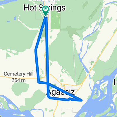
Chilliwack Route
A cycling route starting in Agassiz, British Columbia, Canada.
Overview
About this route
- -:--
- Duration
- 27.8 km
- Distance
- 23 m
- Ascent
- 23 m
- Descent
- ---
- Avg. speed
- ---
- Avg. speed
Route quality
Waytypes & surfaces along the route
Waytypes
Cycleway
20.1 km
(72 %)
Quiet road
6.3 km
(23 %)
Access road
1.4 km
(5 %)
Surfaces
Paved
5 km
(18 %)
Unpaved
21.8 km
(79 %)
Gravel
21.4 km
(77 %)
Asphalt
5 km
(18 %)
Continue with Bikemap
Use, edit, or download this cycling route
You would like to ride Chilliwack Route or customize it for your own trip? Here is what you can do with this Bikemap route:
Free features
- Save this route as favorite or in collections
- Copy & plan your own version of this route
- Sync your route with Garmin or Wahoo
Premium features
Free trial for 3 days, or one-time payment. More about Bikemap Premium.
- Navigate this route on iOS & Android
- Export a GPX / KML file of this route
- Create your custom printout (try it for free)
- Download this route for offline navigation
Discover more Premium features.
Get Bikemap PremiumFrom our community
Other popular routes starting in Agassiz
- Chilliwack Route
- Distance
- 27.8 km
- Ascent
- 23 m
- Descent
- 23 m
- Location
- Agassiz, British Columbia, Canada
- 1135 Hamilton Rd, Agassiz to Chilliwack Lake FSR, Rosedale
- Distance
- 59.1 km
- Ascent
- 1,880 m
- Descent
- 1,236 m
- Location
- Agassiz, British Columbia, Canada
- Yale Road 51630, Chilliwack to Yale Road 52324, Fraser Valley D
- Distance
- 11 km
- Ascent
- 3 m
- Descent
- 7 m
- Location
- Agassiz, British Columbia, Canada
- 1824 Agassiz Rosedale Hwy, Agassiz to 1824 Agassiz Rosedale Hwy, Agassiz
- Distance
- 14.5 km
- Ascent
- 53 m
- Descent
- 51 m
- Location
- Agassiz, British Columbia, Canada
- training
- Distance
- 22.8 km
- Ascent
- 13 m
- Descent
- 13 m
- Location
- Agassiz, British Columbia, Canada
- 51301–51425 Ferry Rd, Chilliwack to 44929–45657 Cartmell Rd, Chilliwack
- Distance
- 15.5 km
- Ascent
- 23 m
- Descent
- 33 m
- Location
- Agassiz, British Columbia, Canada
- Harrison Hot Springs to Surrey
- Distance
- 119.4 km
- Ascent
- 439 m
- Descent
- 375 m
- Location
- Agassiz, British Columbia, Canada
- 2018-09: Agassiz to Fort Langley
- Distance
- 90.6 km
- Ascent
- 432 m
- Descent
- 380 m
- Location
- Agassiz, British Columbia, Canada
Open it in the app