

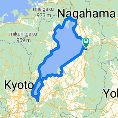
ビワイチ2019
A cycling route starting in Nagahama, Shiga Prefecture, Japan.
Overview
About this route
- -:--
- Duration
- 201 km
- Distance
- 1,508 m
- Ascent
- 1,505 m
- Descent
- ---
- Avg. speed
- ---
- Max. altitude

Route quality
Waytypes & surfaces along the route
Waytypes
Quiet road
42.2 km
(21 %)
Cycleway
32.2 km
(16 %)
Surfaces
Paved
70.4 km
(35 %)
Paved (undefined)
40.2 km
(20 %)
Asphalt
30.2 km
(15 %)
Undefined
130.7 km
(65 %)
Continue with Bikemap
Use, edit, or download this cycling route
You would like to ride ビワイチ2019 or customize it for your own trip? Here is what you can do with this Bikemap route:
Free features
- Save this route as favorite or in collections
- Copy & plan your own version of this route
- Split it into stages to create a multi-day tour
- Sync your route with Garmin or Wahoo
Premium features
Free trial for 3 days, or one-time payment. More about Bikemap Premium.
- Navigate this route on iOS & Android
- Export a GPX / KML file of this route
- Create your custom printout (try it for free)
- Download this route for offline navigation
Discover more Premium features.
Get Bikemap PremiumFrom our community
Other popular routes starting in Nagahama
 Biwaichi, Nagahama to Biwaichi, Nagahama
- Distance
- 0.1 km
- Ascent
- 0 m
- Descent
- 0 m
- Location
- Nagahama, Shiga Prefecture, Japan
 長浜-ビワイチ(反時計回り)(312450)
- Distance
- 153.2 km
- Ascent
- 225 m
- Descent
- 225 m
- Location
- Nagahama, Shiga Prefecture, Japan
 11月4日ビワイチ
- Distance
- 146.9 km
- Ascent
- 368 m
- Descent
- 368 m
- Location
- Nagahama, Shiga Prefecture, Japan
 Easy ride
- Distance
- 85.5 km
- Ascent
- 71 m
- Descent
- 88 m
- Location
- Nagahama, Shiga Prefecture, Japan
 biwaichi
- Distance
- 146.2 km
- Ascent
- 234 m
- Descent
- 235 m
- Location
- Nagahama, Shiga Prefecture, Japan
 ビワイチ2019
- Distance
- 201 km
- Ascent
- 1,508 m
- Descent
- 1,505 m
- Location
- Nagahama, Shiga Prefecture, Japan
 Nagahama to Kyoto
- Distance
- 80.4 km
- Ascent
- 394 m
- Descent
- 425 m
- Location
- Nagahama, Shiga Prefecture, Japan
 Day 15
- Distance
- 96.4 km
- Ascent
- 249 m
- Descent
- 290 m
- Location
- Nagahama, Shiga Prefecture, Japan
Open it in the app