

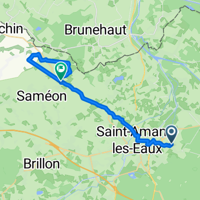
Etappe 4.1: Saint-Amand - Valenciennes
A cycling route starting in Saint-Amand-les-Eaux, Hauts-de-France, France.
Overview
About this route
Saint-Amand - Valenciennes
- -:--
- Duration
- 11.2 km
- Distance
- 54 m
- Ascent
- 62 m
- Descent
- ---
- Avg. speed
- ---
- Max. altitude

Route quality
Waytypes & surfaces along the route
Waytypes
Access road
3.5 km
(31 %)
Quiet road
2.7 km
(24 %)
Surfaces
Paved
8.1 km
(73 %)
Unpaved
0.7 km
(6 %)
Asphalt
8.1 km
(73 %)
Ground
0.7 km
(6 %)
Undefined
2.3 km
(21 %)
Route highlights
Points of interest along the route
Point of interest after 0 km
Camping de l'Orient Rustiek Kamperen, p. 41
Point of interest after 0.1 km
Camping du Mont des Bruyères
Continue with Bikemap
Use, edit, or download this cycling route
You would like to ride Etappe 4.1: Saint-Amand - Valenciennes or customize it for your own trip? Here is what you can do with this Bikemap route:
Free features
- Save this route as favorite or in collections
- Copy & plan your own version of this route
- Sync your route with Garmin or Wahoo
Premium features
Free trial for 3 days, or one-time payment. More about Bikemap Premium.
- Navigate this route on iOS & Android
- Export a GPX / KML file of this route
- Create your custom printout (try it for free)
- Download this route for offline navigation
Discover more Premium features.
Get Bikemap PremiumFrom our community
Other popular routes starting in Saint-Amand-les-Eaux
 Itinéraire reposant en Saint-Amand-les-Eaux
- Distance
- 9.3 km
- Ascent
- 16 m
- Descent
- 16 m
- Location
- Saint-Amand-les-Eaux, Hauts-de-France, France
 Route stable en
- Distance
- 16.2 km
- Ascent
- 12 m
- Descent
- 4 m
- Location
- Saint-Amand-les-Eaux, Hauts-de-France, France
 Berck - Saint-Armand-les-Eaux
- Distance
- 194.3 km
- Ascent
- 290 m
- Descent
- 298 m
- Location
- Saint-Amand-les-Eaux, Hauts-de-France, France
 Etappe 4.1: Saint-Amand - Valenciennes
- Distance
- 11.2 km
- Ascent
- 54 m
- Descent
- 62 m
- Location
- Saint-Amand-les-Eaux, Hauts-de-France, France
 eax escape
- Distance
- 5.6 km
- Ascent
- 4 m
- Descent
- 8 m
- Location
- Saint-Amand-les-Eaux, Hauts-de-France, France
 Paris - Roubaix in 3 Etappen (3b)
- Distance
- 93.9 km
- Ascent
- 178 m
- Descent
- 169 m
- Location
- Saint-Amand-les-Eaux, Hauts-de-France, France
 étape 2
- Distance
- 73.2 km
- Ascent
- 210 m
- Descent
- 126 m
- Location
- Saint-Amand-les-Eaux, Hauts-de-France, France
 De Rue de la Louvière 377, Saint-Amand-les-Eaux à Rue Eugène Millecamps 290, Rumegies
- Distance
- 11.2 km
- Ascent
- 12 m
- Descent
- 4 m
- Location
- Saint-Amand-les-Eaux, Hauts-de-France, France
Open it in the app